Indexed In
- Open J Gate
- RefSeek
- Hamdard University
- EBSCO A-Z
- OCLC- WorldCat
- Publons
- International Scientific Indexing
- Euro Pub
- Google Scholar
Useful Links
Share This Page
Journal Flyer

Open Access Journals
- Agri and Aquaculture
- Biochemistry
- Bioinformatics & Systems Biology
- Business & Management
- Chemistry
- Clinical Sciences
- Engineering
- Food & Nutrition
- General Science
- Genetics & Molecular Biology
- Immunology & Microbiology
- Medical Sciences
- Neuroscience & Psychology
- Nursing & Health Care
- Pharmaceutical Sciences
Research Article - (2022) Volume 11, Issue 2
Viability of On-Orbit Servicing Spacecraft to Prolong the Operational Life of Satellites
Isabella R. Hatty*Received: 10-Mar-2022, Manuscript No. JGRS-22-15762; Editor assigned: 14-Mar-2022, Pre QC No. JGRS-22-15762 (PQ); Reviewed: 28-Mar-2022, QC No. JGRS-22-15762; Revised: 01-Apr-2022, Manuscript No. JGRS-22-15762 (R); Published: 08-Apr-2022, DOI: 10.35248/2469-4134.22.11.216
Abstract
This research paper is an extensive literature review and data analysis on the viability of On-Orbit Servicing (OOS) spacecraft to prolong the operational life of satellites. A systematic analysis of the Union of Concerned Scientists (UCS) Satellite Database found that Sentinel 1A and 1B orbit at approximately the same height as Landsat 7 (~700 km) and have a collective propellant mass (Mprop) of 308 kg which is less than Landsat 7’s 544 kg. The On- Orbit Servicing, Assembly and Manufacturing (OSAM) 1 spacecraft has the capacity to refuel both Sentinels as an alternative option to Landsat 7. For OSAM 1 to refuel Landsat 7, it is $261.91M cheaper than replacement and the more economically viable and sustainable option. OSAM 1 will mitigate the immediate problem of space debris. However, a new model of standardized cooperative satellites with external plug-in interfaces could facilitate both planned and unplanned upgrades, modifications and repairs for changing missions and technology updates for the future.
Keywords
Satellite; Geostationary orbit; Panchromatic range; Spacecraft; Post mission disposal
Introduction
The position of a satellite in orbit is defined by three key parameters; orbital region, inclination and eccentricity. Low Earth Orbit (LEO) satellites occupy Protected Region A (Figure 1) with altitude ZA, 700 km ≤ 2000 km ≤ while Geostationary Earth Orbit (GEO) and Geosynchronous Orbit (GSO) satellites occupy Protected Region B (Figure 1) with altitude (ZB) and inclination (iB) where;

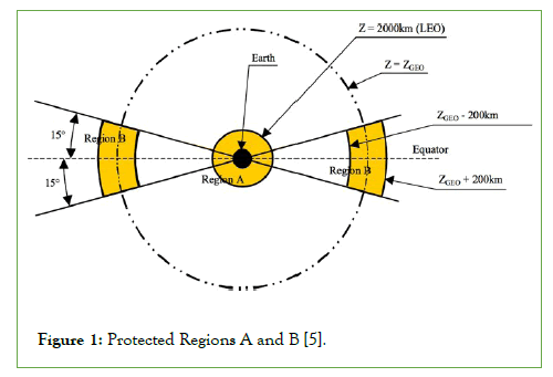
Figure 1: Protected Regions A and B [5].
LEO satellites have close proximity to Earth’s surface, consume less fuel to launch and are more affordable for operators, as a result LEO has the highest satellite population and density. GEO and GSO satellites in Protected Region B are visible from a large area of the Earth’s surface, extending 81° away in both latitude and longitude, and appear stationary in the sky, as a result they have global coverage and eliminate the need for ground stations to have movable antennas [1-4]. A series of collisions in these Regions could seriously impact life on Earth where Protected Region A is particularly vulnerable due to the higher satellite density and velocity.
Space debris mitigation
When satellites reach their End of Life (EOL), there are disposal guidelines in place to mitigate their contribution to space debris. The Inter-Agency Space Debris Coordination Committee (IADC) in tandem with the United Nations Committee on the Peaceful Uses of Outer Space (UNCOPUOS) updated their 2002 “Space Debris Mitigation Guidelines” in 2007 [5,6]. These voluntary Guidelines reflect the fundamental mitigation procedures developed by several national and international organizations [7]. The update reinforces the 25-year post mission orbital lifetime limit or “25-year rule” which states that satellites must undergo Post Mission Disposal (PMD) within 25 years and advises that “immediate removal from Earth orbit” is the preferred disposal option [8]. An ESA study found that GEO satellites have near perfect adherence to the Guidelines, while 80% of LEO satellites that should have undergone re-entry or performed a de-orbit maneuver were left undisposed and abandoned in Protected Region A [1]. The United Nations does not have the authority to police the behaviors of member states; therefore, compliance to the Guidelines relies solely on voluntary adherence. For the United Nations, it is expensive and difficult to monitor non-compliance and for member states, compliance is expensive and requires technical expertise, particularly for developing countries. As a result, the IADC chose not to “name and shame” those who failed to respect the Guidelines as in the global human rights regime [9]. There are financial and technical challenges in the field of space debris mitigation which also apply to space debris remediation in the development of OOS technology.
On-orbit servicing challenges
There are legal, financial and technical challenges for developing OOS technology. Section 2 discusses strategies for overcoming these challenges.
Legal challenges
Launching state liability: The 1972 Outer Space Treaty, the Liability Convention outlines the principles governing the activities of states in the exploration and use of Outer Space [10,11]. These international laws govern, but also challenge the development of OOS. Article 7 of the Treaty states that the “launching state shall be liable to pay compensation for damage caused by its space objects” even after they have sold the object to another state [6]. An amendment to this principle to ensure that the buying state is liable to pay compensation for future damage caused by their object could strengthen interstate trade and increase spacecraft reuse and repurposing. Operators that enter a contract with OOS providers, such as Space Logistics and Astroscale, could also benefit from an amendment. The amendment could ensure that providers are liable to pay compensation for damage caused by the object during OOS, for example, if the provider damages an operational satellite during a failed OOS mission.
Space salvage laws: Wayne White created the first set of “Salvage Laws for Outer Space” in 1992. White proposed that the basic elements of maritime salvage law can be adapted and applied to Outer Space [12]. He states that “(space) debris should be considered abandoned, returned to a state of nature and subject to appropriation or destruction by the first to find it” [12]. The focus of OOS will likely be on large and identifiable objects with a clear owner who can pay for the service; however, large pieces of unidentifiable debris could require the governance of international space salvage laws in the future. An internationally agreed definition of “space debris” could identify those objects that require governance and are therefore, subject to OOS by the first to find it.
Information sensitivity: All members of the supply chain could benefit from sharing detailed information pertaining to on-orbit failures. To the manufacturers, it could ensure that design models are focused on the components with high failure rates and design flaws are rectified. To the insurers, it could enable the design and construction of more reliable models. To the operators, the use of more reliable models could improve mission success and performance in a competitive market and minimise disruption to their services. To the OOS technology developers, it could provide a tighter focus on problem components to maximise availability with minimum cost. As a result, this could encourage manufacturers to build standardised cooperative satellites that reduce the dependence on high cost reliability [13]. Information on the causes of on-orbit failures could be deemed exports and shared internationally using control systems that align with the interests of the country.
Financial challenges
Providers, such as SpaceLogistics and Astroscale, have previously entered contracts with operators to service satellites that are currently in orbit. However, providers could enter an agreement with operators before they launch the satellite as an alternative approach to financing. In addition to purchasing launch and mission insurance, operators could pay a small percentage of the total mission value to an approved provider who carries out OOS missions as required. In 2015, the former Dean of the International Space University, Joseph Pelton, proposed to create a Space Debris Mitigation Fund that receives two types of funding for LEO and GEO satellite launches [6]. There could be two types of payment following this logic.
Type 1: For LEO satellite launches, operators could pay a minimum of 3.5% of the total mission value to the provider. There is greater risk to the mission in LEO than GEO due to the higher satellite density and velocity; therefore, payment is a higher percentage of the total mission value.
Type 2: For GEO satellite launches, operators could pay a minimum of 1.5% of the total mission value to the provider.
Payment Types 1 and 2 provide a baseline approach to financing, but there are additional dependencies, such as the level of technical expertise required to complete the mission, that could impact the amount paid.
Technical challenges
The majority of satellites currently in orbit are non-cooperative or not designed for OOS. A satellite servicing system usually consists of three major components; the servicing spacecraft or chaser, an n-degree-of-freedom (n-DOF) robotic manipulator or arm attached to the servicing spacecraft and the target satellite (Figure 2). The four phases of on-orbit satellite servicing using an OOS spacecraft are outlined in Figure 3 Section 2.3 discusses the challenges for each phase.
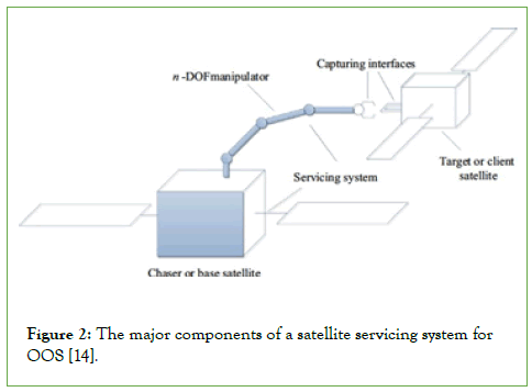
Figure 2: The major components of a satellite servicing system for OOS [14].
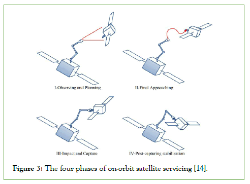
Figure 3: The four phases of on-orbit satellite servicing [14].
Observing and planning: Once the target satellite is identified, the servicing spacecraft performs long and short-range rendezvous maneuvers to inspect the condition of the tumbling satellite to form a capture plan [14,15]. To assist with target identification, satellites could have reflectors installed to signal their location to avoid rendezvous with the wrong satellite [6].
Final Approaching: The robotic arm is manipulated so that it can capture the target satellite [15].
Impact and Capture: The robotic arm physically captures the target satellite and docks [15]. Any inaccuracies or errors in the relative motion of the spacecraft upon impact can affect the trajectory and lead to unwanted tumbling, damage and inability to service. Operators are likely to provide details pertaining to the tumbling status of the target satellite so that the provider can formulate a capture plan.
Post-capturing stabilization: The servicing spacecraft releases, stabilizes and separates from the target satellite [15].
On-orbit servicing missions
Orbital express mission: On the 8 March 2007, the Defence Advanced Research Projects Agency (DARPA) together with NASA spent over $300M to launch the Orbital Express Space Operations Architecture program or Orbital Express mission [16]. The aim of the mission was to determine the technical feasibility of a “safe and cost-effective approach to autonomously service satellites in LEO” [17]. The mission involved two spacecraft; Autonomous Space Transport Robotic Operations (ASTRO), the larger servicing spacecraft, and Next generation of Satellite (NEXTSat), the smaller target satellite envisioned as a prototype for future standardised cooperative satellites [6]. Table 1 shows that Orbital Express successfully demonstrated several service operations, including proximity inspection, capture (Figure 4), docking and berthing, fluid transfer (Figure 5), Orbit Replaceable Unit (ORU) battery transfer and release and separation [15]. Orbital Express proved that OOS is possible and sparked a new era in space operations. Space Drone was planned for launch in 2020 but is delayed due to the COVID-19 pandemic [15-17]. However, the On-orbit, Servicing, Assembly and Manufacturing (OSAM) 1 (Formerly Restore-L) spacecraft, is on track for launch in 2023 and could surpass the achievements of Orbital Express as shown in Table 1.
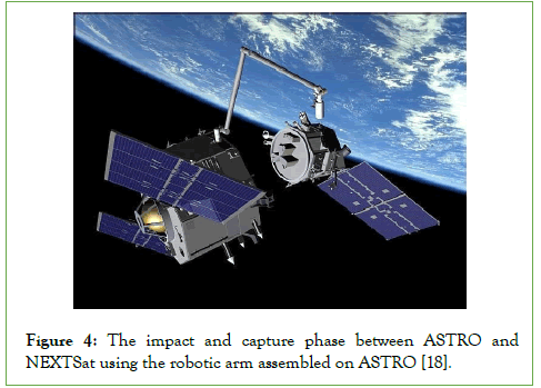
Figure 4: The impact and capture phase between ASTRO and NEXTSat using the robotic arm assembled on ASTRO [18].
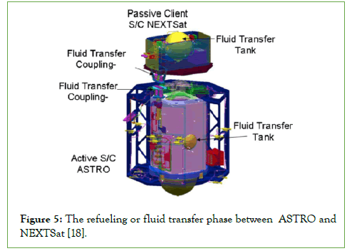
Figure 5: The refueling or fluid transfer phase between ASTRO and NEXTSat [18].
| OOS Mission | Orbital Express | Robotic Refueling Mission | Space Drone | OSAM 1 | ||
|---|---|---|---|---|---|---|
| 2007 | 2018 | 2020 | 2023 | |||
| Cooperative | Non-cooperative | |||||
| Satellite detection | + | + | ||||
| Inspection | + | |||||
| Close-range navigation | + | + | + | |||
| Berthing | + | + | + | |||
| Re-berthing | + | + | + | |||
| Robotic capture | + | + | ||||
| Docking | + | + | ||||
| Undocking | + | + | ||||
| Service operations | + | + | ||||
| On-orbit movement | + | + | + | |||
| Orbit changing | + | + | ||||
| Refueling | + | + | ||||
Table 1: Service operations of OOS missions [15].
OSAM 1
OSAM 1 is currently under development at the Maxar Technologies Palo Alto, California facility and planned for launch in 2023 [18,19]. The aim of the project is to validate a series of on-orbit servicing, assembly and manufacturing capabilities with the first mission to refuel Landsat 7, a non-cooperative, United States Government- owned, Earth observation satellite in LEO (Figure 6). OSAM 1 includes three robotic arms; two attached to a servicing payload to perform highly complex planned and unplanned service operations and one attached to the Space Infrastructure Dexterous Robot (SPIDER) to perform in-space assembly and manufacturing [20]. Figure 7 features the 14’ OSAM 1 spacecraft under development. The small thrusters at both the upper and lower decks of the spacecraft will allow it to maneuver with 6-DOF. This will enable it to execute a “back away” maneuver which is an important capability due to the complexity of the impact and capture phase (Figure 3). The main cylinder of the spacecraft contains two large bipropellant fuel tanks which are shown being installed in Figure 8 and make manoeuvring in space possible [21]. The two silver spheres contain monopropellant fuel that will be used to refuel Landsat 7 [20]. Landsat 7 will be the only refueling mission of OSAM 1, but other missions will include a variety of service operations and in-space assembly and manufacturing.
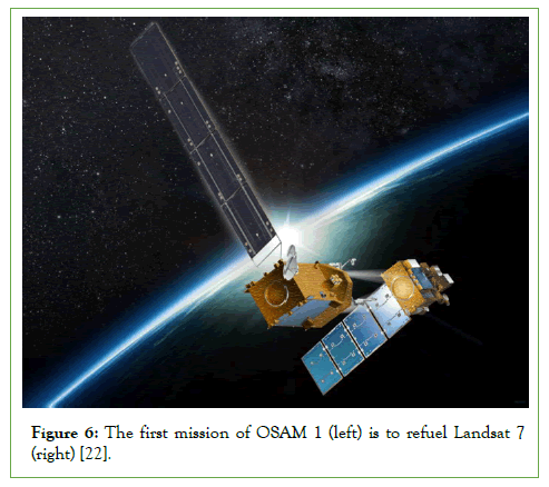
Figure 6: The first mission of OSAM 1 (left) is to refuel Landsat 7 (right) [22].
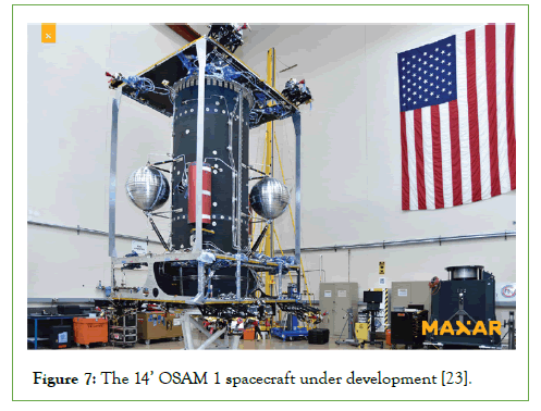
Figure 7: The 14’ OSAM 1 spacecraft under development [23].
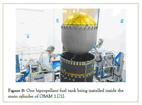
Figure 8: One bipropellant fuel tank being installed inside the main cylinder of OSAM 1 [21].
Landsat 7
On the 15 April 1999, NASA together with the United States Geological Survey (USGS) launched Landsat 7 from the Vandenberg Air Force Base in California [22-24]. Landsat 7 was the most accurately calibrated Earth observation satellite in orbit and carries an Enhanced Thematic Mapper Plus (ETM+) instrument which detects spectrally filtered radiation in four modes; Visible and Near Infrared (VNIR), Shortwave Infrared (SWIR), Panchromatic (PAN) range and Thermal Infrared (TIR) [24]. Figure 9 shows two images that were taken of Chicago, USA by the ETM+ instrument on 19 August 2020; the left is a surface reflectance image and the right is a surface temperature image in units of Kelvin (K) [25]. The goal of Landsat 7 was to provide continuous, high-resolution images of the surface of Earth to help land managers and policymakers make informed decisions about natural resources and the environment [24]. Web mapping services such as Google Maps, MSN Maps and Yahoo are also based on enhanced, color balanced Landsat 7 imagery. Landsat 7 had a design lifetime of 5 years, but it is still operational today after 22 years in orbit. The satellite began its life with a single fuel tank containing 123 kg of monopropellant fuel [26]. On the 7 February 2017, the thrusters were engaged to reduce the altitude and remove the satellite from Protected Region A [24]. This maneuver left Landsat 7 fuel depleted, but able to carry on collecting data with all on-board systems fully functional. The new goal of Landsat 7 is to maintain operations until OSAM 1 is able to complete the refueling and re-orbit mission [24].
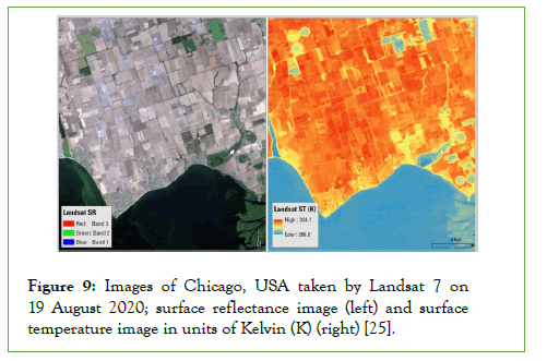
Figure 9: Images of Chicago, USA taken by Landsat 7 on 19 August 2020; surface reflectance image (left) and surface temperature image in units of Kelvin (K) (right) [25].
Methodology
This research paper aims to investigate the viability of OOS spacecraft to prolong the operational life of satellites. An extensive literature review was conducted to understand the current state of OOS technology. Research only included results in English and did not include resources with only the abstract available. The Union of Concerned Scientists (UCS) Satellite Database was last updated on the January 1, 2021 and contains in-depth details on the 3,372 satellites that are currently in orbit around Earth [27]. A systematic analysis of the UCS Satellite Database was performed to identify alternative refueling or servicing opportunities for OSAM 1. OSAM 1 was selected for this analysis as it will demonstrate the service operations of an OOS spacecraft, but it is acknowledged that OOS can take other forms, such as attachable payloads and spacewalking astronauts on the International Space Station. A simple cost-benefit analysis was then performed on OSAM 1 to determine the economic viability of the mission where all dollars are in US Dollars.
Results and Discussion
Systematic analysis
Dry mass (MDry)is the total mass of the satellite excluding the propellant and can be used to estimate the propellant mass (MProp) through subtraction from launch mass (MLaunch). The analysis did not include satellites without dry mass data or MEO and GEO satellites because OSAM 1 will operate in LEO. The following assumptions reduced the number of satellites from 3,372 to 4, including Landsat 7:
Satellite propellant mass and fuel capacity are directly proportional; therefore, OSAM 1 will not have the capacity to fully refuel any satellite with propellant mass that is larger than Landsat 7’s. Therefore, the analysis did not include satellites with a larger propellant mass than Landsat 7.
Satellites operate using monopropellant fuel.
Satellite fuel tanks are accessible by OSAM 1’s robotic arm.
OSAM 1 will commence operations in 2023 and prioritize refueling satellites with expected lifetimes ending in or after 2023 because they are likely fuel depleted. Satellites that have most recently reached their expected lifetimes also have a greater possibility of being fully functional than those that are well passed their expected lifetimes. Therefore, the analysis did not include satellites with expected lifetimes ending before 2023.
Table 2 compares the features and orbital parameters of Landsat 7 and the non-cooperative, ESA-owned, Earth observation (EO) satellites, Sentinel 1A, 1B and 3A. Sentinel 3A has an orbital height of 803 km; therefore, OSAM 1 would consume more fuel to reach Sentinel 3A than Sentinel 1A and 1B which orbit over 100 km closer to Earth and 4 km apart at 692 km and 696 km. Additionally, the total propellant mass of Sentinel 1A and 1B is 308 kg which is 236 kg less than Landsat 7’s propellant mass of 544 kg; therefore, OSAM 1 has the capacity to refuel both Sentinel 1A and 1B in one mission and reserve the leftover fuel for other unplanned missions. OSAM 1 is specifically designed to refuel a 544 kg fuel tank with Landsat 7’s orbital parameters; the Sentinel’s 154 kg fuel tanks have similar orbital parameters to Landsat 7 which could make them compatible for refueling by OSAM 1. If the United States Government could enter a contract with ESA to align their interests, this could be a more valuable alternative to refueling only the one Landsat 7 satellite, but further analysis is required. Although most satellites in orbit are non-cooperative, providers could design their OOS spacecraft to target the common features between them to be compatible with a larger group of satellites.
| Satellite | Landsat 7 | Sentinel 1A | Sentinel 1B | Sentinel 3A |
|---|---|---|---|---|
| MLaunch (kg) | 2,744 | 2,300 | 2,300 | 2,300 |
| MDry (kg) | 2,200 | 2,146 | 2,146 | 2,146 |
| MProp (kg)Prop | 544 | 154 | 154 | 154 |
| Date of Launch | 15-04-1999 | 03-04-2014 | 25-04-2016 | 16-01-2016 |
| Expected Lifetime (yrs) | 15 | 7 | 7 | 7 |
| Orbital Height (km) | 702.5 | 692 | 696 | 803 |
| Inclination (°) | 98.2 | 98.16 | 98.1 | 98.6 |
| Period (mins) | 98.8 | 98.61 | 98.7 | 100.9 |
| Country of operator | USA | ESA | ESA | ESA |
| Purpose | EO | EO | EO | EO |
Table 2: The features and orbital parameters of the Landsat 7 and Sentinel satellites.
Economic analysis
There are currently two options for the fuel depleted Landsat 7 satellite; replace or refuel. Landsat 9 is planned for launch in late 2021 and will feature the newest technology as the latest addition to the Landsat series. Once operational, Landsat 8 and 9 will acquire around 1,500 high-quality images of Earth per day [28]. This analysis used the manufacture cost (CManu) and (MLaunch) data of Landsat 9 to model the replacement satellite. Table 3 outlines the features and costs of both options where (CManu) and (MLaunch) of the refueling mission are inclusive of the servicing payload and SPIDER on OSAM 1. The Ariane 62 launch vehicle is currently under development and scheduled for its first test flight in 2022. The analysis assumed that the replacement satellite and OSAM 1 are launched into orbit with a 100% success rate by this vehicle which can lift 10,350 kg into LEO at a cost of $75 M [29-31]. Equation. 1 calculates the cost to launch (CLaunch) the replacement satellite and OSAM 1 by rearranging the ratio below.
| Replace | Refuel | ∆ Cost | |
|---|---|---|---|
| CManu | $517M | $227M | $290M |
| MLaunch(kg) | 2,623 | 6,500 | - |
| CLaunch | $19.01M | $47.10M | $28.09M |
| CTotal | $536.01M | $274.10M | $261.91M |
| Benefits | Improved satellite technology | Current Landsat 7 technology & additional OSAM 1 operations | - |
Table 3: The features and costs of the replacement and refueling options for Landsat 7 [28,30,31].
MLaunch : CLaunch
10, 350: $75M
(MLaunch/ 10,350) ×75 = CLaunch (1)
Table 3 shows that the refueling option is $261.91M cheaper than replacement. The additional benefits of this option include the continued service of Landsat 7 and the variety of assembly and manufacturing operations that OSAM 1 will perform post refueling Landsat 7. The analysis acknowledges that Landsat 7 has significant image artifacts after 2 decades in orbit. The replacement satellite would have no such limitations and the updated technology could return the initial expense of the mission. This analysis did not quantify these values but estimated that the return benefits of Landsat 7 and OSAM 1 will ultimately outweigh those of the replacement satellite. Refueling Landsat 7 is the more economically viable and sustainable option.
Future recommendations
All operators could benefit from OOS because on-orbit satellite accidents, failures and fuel depletion are inevitable occurrences. The Orbital Express mission successfully demonstrated OOS of a cooperative satellite and OSAM 1 will service a non-cooperative satellite which makes up the vast majority that are currently in orbit. The technology to service non-cooperative satellites will no doubt develop first to address the immediate problem of space debris. However, the technology to follow could be a new model of standardized, cooperative satellites with external plug-in interfaces, much like Orbital Express’ NEXTSat. This would facilitate both planned and unplanned upgrades, modifications and repairs for changing missions and technology updates. It could also spark a new era of sustainable space operations with high economic viability.
Conclusion
OOS spacecraft can viably prolong the operational life of satellites. The Orbital Express mission proved that the legal, technical, and financial challenges can be overcome to successfully complete OOS of cooperative satellites. The OSAM 1 mission will demonstrate a series of on-orbit servicing, assembly and manufacturing capabilities with the first mission to refuel the non-cooperative Landsat 7 satellite. The Sentinel 1A and 1B satellites orbit at approximately the same height as Landsat 7 (~700 km) and have a collective propellant mass of 308 kg which is less than Landsat 7’s 544 kg. OSAM 1 has the capacity to refuel both Sentinels in one mission which could be more valuable than refueling the single Landsat 7 satellite. There are currently two options for the fuel depleted Landsat 7 satellite; replace or refuel. The refueling option is $261.91M cheaper and more sustainable than replacement. A new model of standardized, cooperative satellites with external plug-in interfaces could spur the next generation of sustainable space operations.
REFERENCES
- ESA. "Time to Act." Aired20. 2021.
- O’Callaghan J. What is Space Junk and why is it a problem. 2019; 5.
[Google scholar] [Indexed].
- JPL. Waste In Space, California Institute of Technology.2012.
- Soler T, Eisemann DW. Determination of look angles to geostationary communication satellites. J.Surv. Eng.1994;120(3):115-127.
[Crossref], [Google scholar], [Indexed]
- Mejía-Kaiser M. Iadc Space Debris Mitigation Guidelines; In The Geostationary Ring.2020;381-389.
- Pelton JN. New solutions for the space debris problem. Cham: Springer International Publishing. 2015.
- Mejía-Kaiser M. Space Debris Mitigation Guidelines of the Committee on the Peaceful Uses of Outer Space, United Nations. In The Geostationary Ring 2020; 390-394.
[Crossref], [Google scholar]
- USG. Orbital Debris Mitigation Standard Practices. 2019; 1-8.
- Chiu SW. Promoting international co-operation in the age of global space governance–A study on on-orbit servicing operations. Acta Astronaut. 2019;161:375-381.
[Crossref], [Google scholar], [Indexed].
- Barnhart D, Sullivan B. Economics of repurposing in situ retired spacecraft components. In AIAA SPACE 2012 conference & exposition 2012.5304.
[Crossref], [Google scholar].
- Burke JA. Convention on International Liability for Damage Caused by Space Objects: Definition and Determination of Damages After the Cosmos 954 Incident. Fordham Int. Law J. 1984;8:255.
[Crossref], [Google scholar], [Indexed].
- White W. Salvage Law for Outer Space. Engineering, Construction and Operations in Space III International Conference, Denver, USA, Academia. 1992.
- Ellery A, Kreisel J, Sommer B. The case for robotic on-orbit servicing of spacecraft: Spacecraft reliability is a myth. Acta Astronaut. 2008; 63(5):632-48.
[Crossref] [Google scholar].
- Flores-Abad A, Ma O, Pham K, Ulrich S. A review of space robotics technologies for on-orbit servicing. Prog. Aerosp. Sci. 2014; 68:1-26.
[Crossref] [Google scholar].
- Kozlova NY, Fomichev AV. Promising on-orbit servicing tasks for spacecraft life extension. AIP Conf Proc. 2021; 23189(1):130008.
[Crossref] [Google scholar].
- Friend RB. Orbital express program summary and mission overview. Int. j. opt. photonics. 2008; 6958: 695803.
[Crossref] [Google scholar].
- Boeing. "Boeing Integrated Defence Systems - Orbital Express."2021.
- Li WJ, Cheng DY, Liu XG, Wang YB, Shi WH, Tang ZX, et al. On-orbit service (OOS) of spacecraft: A review of engineering developments. Prog. Aerosp. Sci. 2019; 108:32-120.
[Crossref] [Google scholar].
- MAXAR. "OSAM-1 Passes Accommodation CDR, Propulsion System Module Complete." 2021.
- Patane S, Abromitis K, Acosta Quiros G, Shestople P, Kieler D, Snyder MP. On-orbit Servicing, Assembly, and Manufacturing (OSAM) Enhancing Climate Research.2021.4189.
[Crossref] [Google scholar].
- MAXAR."OSAM-1 Continues to Make Progress, Fuel Tank Installed." 2020.
- Lymer J. Pioneering the Next Era of Space Operations and Exploration. 2021.
- NASA."NASA’s On-orbit Servicing, Assembly, and Manufacturing 1 Mission Ready for Spacecraft Build." 2021.
- USGS. Successful Maneuver Spells Beginning of the End for Landsat 7. 2021.
- Bouchard, M. Example of the Landsat 7 ETM+ Collection 2 level-2 science products, United States Geological Survey USGS. 2020.
- Schaeffer BA, Iiames J, Dwyer J, Urquhart E, Salls W, Rover J, et al. An initial validation of Landsat 5 and 7 derived surface water temperature for US lakes, reservoirs, and estuaries. Int. J. Remote Sens.2018; 39(22):7789-7805.
[Crossref] [Google scholar].
- UCS. UCS Satellite Database. 2021.
- CRS. Landsat 9 and the Future of the Sustainable Land Imaging Program: 1. 2020.
- Gallois. D."Ariane 6, a European project to stay in the space race." 2019.
- Foust. J."NASA space technology faces potential budget pressure." 2020.
- Shoemaker MA, Vavrina M, Gaylor DE, Mcintosh R, Volle M, Jacobsohn J. OSAM-1 decommissioning orbit design. 2020.
[Google scholar] [Indexed].
Citation: Hatty IR (2022) Viability of On-Orbit Servicing Spacecraft to Prolong The Operational Life of Satellites J Remote Sens GIS. 11:216.
Copyright: © 2022 Hatty IR. This is an open-access article distributed under the terms of the Creative Commons Attribution License, which permits unrestricted use, distribution, and reproduction in any medium, provided the original author and source are credited.

