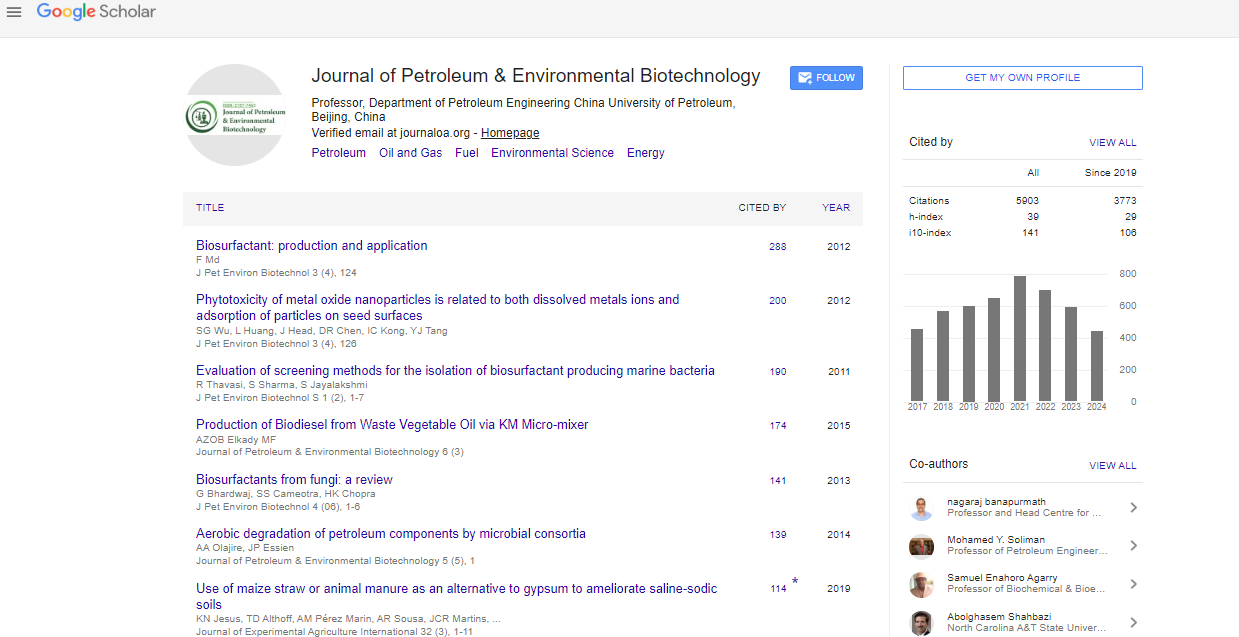
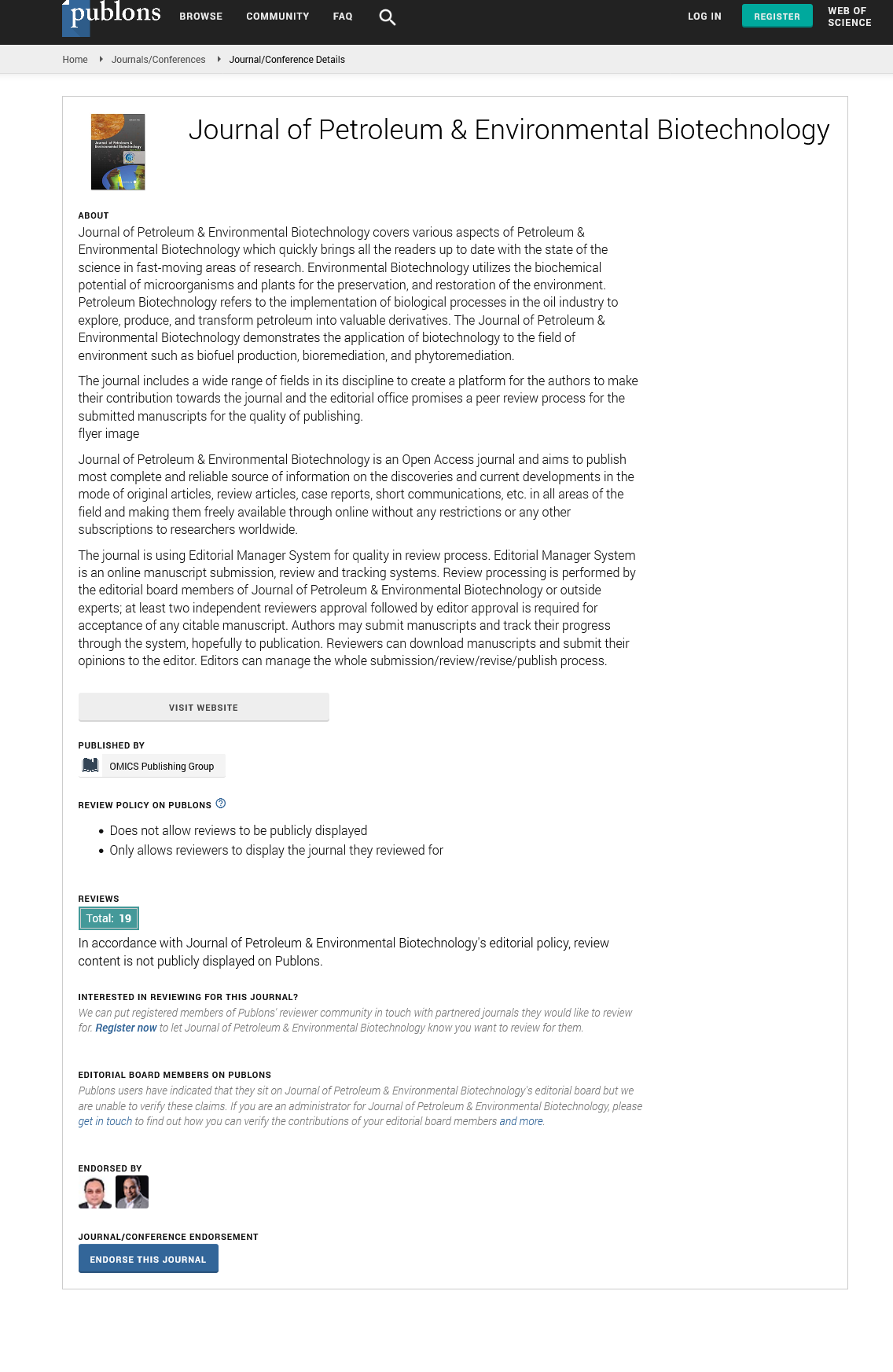

Indexed In
- Open J Gate
- Genamics JournalSeek
- JournalTOCs
- China National Knowledge Infrastructure (CNKI)
- Electronic Journals Library
- RefSeek
- Hamdard University
- EBSCO A-Z
- OCLC- WorldCat
- SWB online catalog
- Virtual Library of Biology (vifabio)
- Publons
- MIAR
- Euro Pub
- Google Scholar
Useful Links
Share This Page
Journal Flyer
Open Access Journals
- Agri and Aquaculture
- Biochemistry
- Bioinformatics & Systems Biology
- Business & Management
- Chemistry
- Clinical Sciences
- Engineering
- Food & Nutrition
- General Science
- Genetics & Molecular Biology
- Immunology & Microbiology
- Medical Sciences
- Neuroscience & Psychology
- Nursing & Health Care
- Pharmaceutical Sciences
Commentary - (2022) Volume 13, Issue 4
Use of Satellite Technologies for Coal Exploration
Claus Petersen*Received: 01-Apr-2022, Manuscript No. JPEB-22-16524; Editor assigned: 05-Apr-2022, Pre QC No. JPEB-22-16524(PQ); Reviewed: 19-Apr-2022, QC No. JPEB-22-16524; Revised: 26-Apr-2022, Manuscript No. JPEB-22-16524(R); Published: 03-May-2022, DOI: 10.35248/2157-7463.22.13.459
Description
Coal is the primary source of energy. China and Vietnam have a lot of coal resources, but there isn't much exploring going on. Complex geological features, inefficiency, associated degradation, and other undesirable situations are the main causes. To accomplish this, you'll need to employ modern technologies to ensure that your resource research goes as planned. Remote sensing techniques have been proved in numerous studies to be a viable way for coal discovery and assessment. This paper uses satellite data to estimate the distribution and reserves of open field coalfields. Satellite photos of outdoor coal-producing sites in Quang Ninh Province, Vietnam, were obtained as experimental data. To begin, reduce spectral interference from satellite photos using ENVI software [1]. The revised ELM algorithm was then implemented following that, the enhanced ELM algorithm creates an image categorization model. Finally, MATLAB simulation is used to verify the enhanced ELM algorithm's effectiveness. The test set's accuracy is 96.5 percent, according to the results. When compared to the identical image from Google, it scores an image recognition accuracy of 83 percent.
Remote sensing is a technique for gathering, transmitting, analyzing, and extracting geographic data without coming into direct contact with the earth's surface. Remote sensing technology has advantages over traditional methods such as "multi-point," "multi-band," and "temporal." At the same time, data from wavelengths far beyond the visible spectrum can be captured, extending the observation range [2]. Repeated remote sensing measurements can reveal the developmental trajectory of objective phenomena in the time dimension. Remote sensing technology has been successfully employed in the sectors of forestry, agriculture, geology, and marine ecology for the past 20 years. Surprisingly, remote sensing is also an important information source in resource and environmental studies. When researching coal mining sites, remote sensing technology enables access to a wide range of information about coal mining areas despite the constrained geographical conditions.
This method has been successfully applied to coal exploration and measurement. Through Taiyuan coal space remote sensing experimental research, Guan indicated that aerial remote sensing data may be applied to coal prediction [3]. In Hunan Xuefeng Coal satellite photos, Zou investigated the relationship between annular images, gravity, and magnetic anomalies. Using the annular image, they discovered coal in the Hunan Cenozoic cap. Mularz surveyed the brown coal mining area of the Belchatow open pit and SPOT5 at various areas using several remote sensing reports of Landsat and SPOT5 data, as well as aircraft remote sensing data and other information. Finally, panchromatic fusion was used to derive change data for the mining region Time and TM multispectral images. Cloutis discovered the effect of exploitation coal mine underground in the Ruhrgebiet area of Germany using hyperspectral remote sensing data, interfering radar data, and GPS positioning measurement techniques. Through a survey of TM pictures of Huabei coal, geological events beneath the topsoil have been discovered to directly or indirectly affect soil layer or surface features (such as flora) [4]. It can be used to find geochar that has been concealed. A new multiband, multi-polarization, and multi angle method for analyzing remote sensing data and exploring the geology of deep level coal information was recently introduced. Many studies have proven that remote sensing technology is a useful tool for locating coal resources.
In the field of remote sensing satellite imaging, Pankiewicz technology is commonly employed to determine diverse images. Unsupervised classification, supervised classification, and neural networks are the three types of classification methods. The most frequent unsupervised classification methods include the nearest neighbor approach, histogram method, and clustering method. Nearest neighbor algorithms, maximum likelihood estimation, and support vector machines are among the methodologies under scrutiny. The neural networks PNN (Probability Neural Network), BP (Backpropagation), and SOM (Self Organized Feature Map) are the three types of artificial neural networks used in satellite image classification.
As is well known, the number of varieties of remote sensors is growing, and remote sensing picture resolution is improving. The correct processing, development, and implementation of analytical tools, on the other hand, has been put off. Traditional satellite imagery categorization algorithms can result in massive, concentrated minor issues [5]. As a result, classification accuracy and speed are much below what is required. As a result, in the field of remote sensing, the development of accurate and quick automatic categorization algorithms for satellite images has always been a contentious issue.
To that aim, this work offers a new single hidden layer feedforward Extreme Learning Machine (ELM) and algorithms for building a classifier for remote sensing satellite images classification. This innovative algorithm can learn new things quickly and accurately while approaching complex continuous functions. Remote sensing technology, on the other hand, has been frequently utilized in mining areas since 1970. However, because of the unknown spectral properties, most of these methods are subjective and time consuming. To enhance classification accuracy, the same experiment must be repeated. Spectral properties, on the other hand, can provide additional information, Based on the spectral features of satellite photos, we present a method for finding and measuring coal. First, use ENVI software to remove spectral image data interference. Then, for building a charcoal image classification model, we propose an improved ELM algorithm. Finally, satellite photos of the Quang Ninh coal field in Vietnam are classified using the coal image classification model. The suggested technique exceeds many standard neural networks, according to simulation findings.
REFERENCES
- Tian F, Wang Y, Fensholt R, Wang K, Zhang L, Huang Y. Mapping and evaluation of NDVI trends from synthetic time series obtained by blending Landsat and MODIS data around a coalfield on the Loess Plateau. Remote Sens. 2013; 5(9):4255-4279.
- Huang GB, Zhu QY, Siew CK. Extreme learning machine: a new learning scheme of feedforward neural networks. IEEE Xplore. 2004; 2:985-990.
- Huang GB, Zhu QY, Siew CK. Extreme learning machine: theory and applications. Neurocomputing. 2006; 70(1-3):489-501.
- Huang GB. An insight into extreme learning machines: random neurons, random features and kernels. Cognit Comput. 2014; 6(3):376-390.
- Zou YY. Application and achievements of remote sensing to explore coal resource under mesozoic-cenozoic cap rock in Hunan Province. Coal Geol China. 1993; 5(3):58-60.
Citation: Petersen C (2022) Use of Satellite Technologies for Coal Exploration. J Pet Environ Biotechnol. 13:459.
Copyright: © 2022 Petersen C. This is an open-access article distributed under the terms of the Creative Commons Attribution License, which permits unrestricted use, distribution, and reproduction in any medium, provided the original author and source are credited.