Indexed In
- Open J Gate
- RefSeek
- Hamdard University
- EBSCO A-Z
- OCLC- WorldCat
- Publons
- International Scientific Indexing
- Euro Pub
- Google Scholar
Useful Links
Share This Page
Journal Flyer

Open Access Journals
- Agri and Aquaculture
- Biochemistry
- Bioinformatics & Systems Biology
- Business & Management
- Chemistry
- Clinical Sciences
- Engineering
- Food & Nutrition
- General Science
- Genetics & Molecular Biology
- Immunology & Microbiology
- Medical Sciences
- Neuroscience & Psychology
- Nursing & Health Care
- Pharmaceutical Sciences
Research Article - (2024) Volume 13, Issue 1
Site Suitability Analysis for Waste to Energy Facility in Onitsha North Local Government Area, Anambra State, Nigeria
Muhammad Isma’il**Received: 17-Jan-2024, Manuscript No. JGRS-24-24633; Editor assigned: 22-Jan-2024, Pre QC No. JGRS-24-24633 (PQ); Reviewed: 05-Feb-2024, QC No. JGRS-24-24633; Revised: 12-Feb-2024, Manuscript No. JGRS-24-24633 (R); Published: 19-Feb-2024, DOI: 10.35248/2469-4134.24.13.329
Abstract
Onitsha North in Anambra State is an industrial and commercial city in south eastern Nigeria that is currently faced with twin problems of poor waste management and epileptic power supply. Exploiting the huge waste energy potentials in the area through Waste to Energy (WTE) technology is an efficient and sustainable waste management strategy that can be deployed in order to boost the energy supply mix in the area. However, the viability of WTE adoption has not been investigated, because the basic geographic information for exploiting WTE potential is presently lacking in spite of the huge potentials in the area. As a first and critical step to address this problem, this study combined Geographic Information System (GIS) and Multi-criteria Decision Analysis (MCDA) techniques to identify suitable sites for WTE facility in Onitsha North with a view to determining the viability of adopting WTE in the area. Relevant geographic factors were assigned weights using the Analytic Hierarchy Process (AHP) and analysed using the Weighted Overlay method in ArcGIS environment to produce suitability map for WTE facility in the study area. Findings revealed various categories of suitability ranging from areas that are moderately suitable and marginally suitable to those areas that are less suitable and not suitable for siting WTE facility. The study has provided the basic information required for harnessing waste energy potential for sustainable development in Onitsha North. Lack of the basic information for implementing WTE technology has hindered the exploitation of huge waste energy potentials in the area. This study has shown that WTE can be adopted as an alternative efficient waste management strategy to provide alternative energy source for industrialisation and economic activities in the area. The combination of GIS and MCDA techniques has proven to be efficient in site suitability analysis; hence it can be applied in solving multi-criteria decision problems.
Keywords
Municipal solid waste; Waste to energy; Site suitability; Geographic Information System (GIS); Multicriteria Decision Analysis (MCDA)
Introduction
One of the environmental challenges of African cities such as Onitsha in south eastern Nigeria is managing the huge amount of waste generated resulting from rapid population growth and increasing economic activities in the cities [1]. African cities are also confronted with poor electricity supply for domestic and economic activities [2]. Nigeria has an estimated population of over 200 million people with annual Municipal Solid Waste (MSW) generation of about 32 million tonnes (0.438 kg/person/day) [3]. The country has about 14 million tonnes of combustible waste [4]. The country’s annual electricity generation potential from MSW was estimated at 26,744 GWh/year [5]. Annual waste generation in the country will increase from 26,600 GWh/year in 2015 to 36,250 GWh/year by 2030 and Methane emission which was 491 Gg for 2015 is projected to reach 669 Gg in 2030 [6]. Energetic valorization of the combustible waste (5,757,363 tons) in Nigeria has energy potential of about 947,981.3 MWh, with monetary value of $131.7 million [7].
In Nigeria, inefficient waste management and poor electricity supply are some of the main challenges of development in the country [2,8]. In this country, where access to energy is a great challenge to majority of the population, energy recovery from waste (Waste to Energy) can play a vital role in minimising the environmental impact of MSW with the additional benefit of providing alternative source of energy [9]. Waste to Energy (WTE) is among the most viable options for sustainable waste management [10].
Waste to Energy technology is the concept of using non-recyclable waste and converting it into electricity, heat or fuel. WTE technology is a facility or plant such as incinerator, anaerobic digester, methanation plant or compost plant which can provide alternative to the fossil fuel energy supply of a city or complement the city’s energy supply mix through renewable sources has shown how to estimate MSW generation and how the waste energy potential in Pune city of India is estimated [11,12]. There is enormous renewable energy potential from MSW which can be exploited through waste incineration or landfilling with gas capture system and other WTE technologies [13]. WTE has the advantage of reducing the municipalities’ budget in developing countries, where waste management spending constitutes from 20% to 50% of their available budget, as well control pollution and generate surplus energy [9]. Another advantage WTE is MSW reduction and conversion into useful energy [14].
Among the waste disposal techniques, incineration has the additional advantages of reducing the volume and quantity of waste and it is less harmful to the environment in the longterm [15]. However, siting a MSW incineration plant requires a comprehensive assessment to determine the ideal locations that can concurrently meet the authorities’ regulations and minimise economic, environmental, health, and social costs. This is because MSW incinerators are still perceived as great sources of pollution [16]. Inappropriate siting of incinerators may result into strong harmful impact from its operation on neighbourhood and contribute to environmental degradation.
Selecting appropriate site for a solid WTE plant is necessary to mitigate its environmental impacts. To achieve this, exclusive and suitable criteria that determine viability and sustainability of the WTE plant site are considered [9]. Several approaches have been used by researchers to determine the optimal locations for WTE facility. For instance, presented a spatial multi-criteria evaluation approach to assess land suitability for a plant siting in Santiago Island of Cape Verde [16]. It combines the Analytical Hierarchy Process (AHP) to estimate the selected evaluation criteria weights with Geographic Information Systems (GIS) for spatial data analysis. The results showed that the methodology is reliable.
Presented an optimisation model incorporated with GIS data inputs for MSW management [13]. Apart from the ability to and determine the optimal site for the establishment of new WTE power plants, the model is capable of forecasting the appropriate type of WTE conversion technology to be adopted in a given site. Provided another alternative method which developed a GIS-based model for siting a MSW incineration power plant in Alexandria governorate, Egypt [10]. Five criteria were considered and a composite index was suggested to integrate these criteria quantitatively reflecting suitability of various parts of the governorate for siting WTE plant. Likewise, proposed a spatial model for solid waste management and reduction [17]. The model would help in determining suitable site for waste disposal and composting.
In order to solve the problem of waste management, an improved multi-group VIKOR method was proposed by to select the optimal site for WTE. The factors considered for site selection of the WTE plant were production factors, land, policy, environmental and social factors. The nobility of this method by lies in its integration of the public satisfaction whereby the people were involved as an evaluation group rather than creating general indicators to represent the public acceptance as it has been done by previous researchers [15]. Also, developed an uncertain AHP model by integrating MCDA methods and a GIS for locating the most suitable facility sites in MSW management, and its application to an incineration facility in Izmir metropolitan municipality of Turkey [18]. The approach was noble for including a pre-screening process for the exclusion of unsuitable areas.
Similarly, in order to address the increasing amounts of waste which has burdened the existing solid waste management system in Oman, proposed establishing incineration plants that can considerably reduce the volume of waste and can simultaneously produce electricity [19]. The study combined GIS and MCDA for the selection of an appropriate site for an incineration plant that can mitigate environmental impact and eliminate community dissatisfaction.
Selecting appropriate locations for WTE plant is critical in order to mitigate the adverse impact from its operation on local communities and the surrounding environment. Hence, several studies as observed from the foregoing literature review have used different approaches such as GIS, MCDA, combined GIS and MCDA to identify suitable sites for WTE facility or plant in order to achieve sustainable waste management. It is also observed from the literature review that different researchers considered various factors that are relevant to their specific geographical locations for site suitability analysis of WTE facility, as there are no uniform factors for all geographical locations. However, in spite of the effectiveness of the different methodologies and approaches as reported in the literature, application of GIS and MCDA for site suitability analysis of WTE facility in cities across Nigeria is very limited. There is also a lack of real scientific information that could motivate WTE development in the country [8].
Some studies have been carried out on WTE potentials in Nigeria. Examined the current energy scenario in Nigeria in terms of production and how the underlining issues can be addressed by developing local capacity in energy from waste technology [20]. Their findings revealed that the residual waste in Abuja and Lagos cities can generate 54 GWh/year and 475 GWh/year respectively. Investigated the energy generation potential and economic viability of organic MSW in the 21 LGAs of Anambra State of Nigeria [21]. They found that a large-scale plant of about 50 m3 can possibly be installed at all the LGAs including Onitsha North. Conducted an assessment of the technical and economic potentials of recovering energy from the MSW generated in Yola metropolis of Nigeria based on the incineration technology method [22]. Their findings revealed that the average calorific value of the MSW disposed of in the city’s dumpsite is 1515.67 kcal/kg, with the potential to produce a total of 3,748.60 kW of electrical energy from the three dumpsites studied. Carried out an exploration and prediction of wet season MSW for power generation in Ilorin metropolis, Nigeria [23]. The estimated electrical power potential for the wet season MSW is capable of meeting about 59% of the power demand for the metropolis. Results showed that the estimated electrical power potential of 4.2 GWh for the wet season MSW is capable of meeting about 59% of the power demand for the Ilorin metropolis [1]. Examined the energy potential of waste generated in Nigeria from different recovery methods. The study used available organic fraction of MSW generation data for each of the state capitals in the country to estimate energy potential from different technologies. Determined the electric power generation potential of MSW in Abuja, the capital city of Nigeria [24]. The study found that with an annual MSW generation rate of 973,557 tons and a per capita generation of 0.77 kg/day, 9.2 × 10⁹ MJ/annum of energy can be recovered from the waste. Based on this, Abuja’s MSW can support a power generating plant with a capacity of 128 MW which exceeds the current energy supply of about 80 MW to the city. Also, carried out site suitability analysis for waste to energy plant in Kaduna metropolis [25]. This study used GIS and MCDA to show the viability of WTE implementation in the metropolis.
Onitsha North is an industrial and commercial city in in Anambra State of south eastern Nigeria that is currently facing poor electricity supply and serious environmental problems resulting from poor solid waste management. This is in spite of the enormous waste energy potentials in the city. Onitsha has MSW generation of 41,951 Mg/yr and per capita waste generation of 0.53 kg/capita/day [8]. The rate of solid waste generation in the city has increased with rapid urbanisation, population and economic growth. Indiscriminate waste disposal is a common feature of the city. The daily waste generation of about 205,538 kg/day in Onitsha is composed of majorly organic and paper, followed by plastics and glass as well as textile and metal [7]. The solid waste management practice in Onitsha is not different from that of the capital city, Awka in Anambra State, which is generally poor and inefficient in spite of the several efforts that have been made to improve the situation [24]. Although efforts are being made by the government and institutions in managing waste generated in the area, huge percentage of the waste is still not adequately managed [26]. Onitsha North is also reported to have huge bio-wastes with annual cumulative generation of 3,992,735 kg and estimated biogas potential of 273.18 kWe [27].
The huge waste energy potentials in Onitsha have not been exploited to assist in solving the electricity supply problem in the city. According to the load demand record of Enugu Electricity Distribution Company for the year ending 2019, power supply in Onitsha and its environs is approximately 104 MW.93, but the utility company could only supply 6 MW out this. The inability of the utility company to provide industries adequate power supply has resulted to an epileptic power supply in the city, hence, the power distribution companies carry out load shedding as a mitigation strategy [28].
The huge amount of waste generated in Onitsha North provides an opportunity for WTE generation as an efficient waste management strategy and also an alternative energy source in order to meet increasing energy demand in the area. However, one of the challenges of WTE research is that reliable databases on the waste generation and management techniques in the cities of Nigeria are not available [22]. Also, site selection for WTE plant which is critically important in waste management system has not been examined by previous studies in Onitsha North. In fact, the basic information for exploiting WTE potentials in the study area is presently lacking and therefore, preliminary assessment for WTE implementation has not been conducted. Hence, the aim of this study is to determine the specific multiple factors that influence site suitability analysis for WTE facility in Onitsha North and to identify suitable sites for WTE facilities in the area. This will help in providing some of the required information for efficient waste management and providing alternative source of electricity in the area.
Materials and Method
The study area
Onitsha North LGA in Anambra State is located within Latitudes 6°06’41”N to 06°12’20”N of the Equator and Longitude 06°43’20”E to 06°50’20” of the Greenwich meridian. It has a landmass of 36.12 km2 and is bounded by Idemili-North LGA to the east, to the west by River Niger, to the south by Onitsha-South LGA, and to the north by Oyi and Anambra-East LGAs. The climate of the study area is the tropical rainforest, characterised by two seasons, the rainy season (March–October) and the dry season (November– February). The annual rainfall is about 1300 mm. Annual average temperature ranges from a minimum of 20.78°C to a maximum of 30.24°C. Relative humidity ranges from annual minimum of 34% in dry season to a maximum of 89% in rainy season (Figure 1) [26].
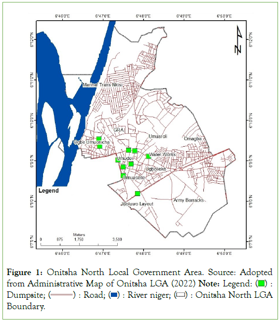
Figure 1: Onitsha North Local Government Area. Source: Adopted from Administrative Map of Onitsha LGA (2022) Note: Legend:  Dumpsite;
  Onitsha North LGA Boundary.
Types and sources of data
The data used for this study include coordinates of existing dumpsites, the Shuttle Radar Topographic Mission (SRTM) Digital Elevation Model (DEM) with 30 m resolution, the road and water bodies in the study area as well as Landsat 7 (ETM) of 2020. Landsat ETM+ image data has eight spectral bands, with a spatial resolution of 30 meters for bands 1 to 5 and band 7. Resolution for band 6 (thermal infrared) is 60 meters and resolution for band 8 (panchromatic) is 15 meters. These data were obtained from both primary and secondary sources (Table 1).
| Data | Source | Purpose |
|---|---|---|
| Administrative map of Onitsha North LGA at a scale of 1:50,000 | Urban planning section in the ministry of lands and physical planning, Anambra State | To identify spatial features like roads, rivers, residential area |
| Geographic coordinates of existing dumpsites in the study area. | Garmin E-trex R 20x handheld GPS receiver | To locate the existing dumpsites |
| SRTM imagery of the area | The United States Geological Survey (USGS) | To determine the elevation of the terrain |
| Landsat 7 (ETM) of 2020 | Landsat (Glovis) websites | Generate land-use map |
| Road network | Open street map | Buffer of distance to road |
| Water body | Open street map | Buffer of distance to water body |
Table 1: Types and sources of data.
Data analysis
The SRTM data was used to extract the DEM and the slope map of the study area using the 3D spatial analyst tool in ArcGIS environment, whereas the road and waterbody shapefiles were extracted from Open Street Map. Other secondary data used were information on waste management and the situation of the dumpsites in the study area documented by the Anambra State Environmental Protection Agency (ANSEPA) and the MSW agencies in the LGA.
The land Use/Land Cover (LULC) map of the study area was extracted from Landsat ETM imagery. The ERDAS Imagine software was used for image classification. A supervised classification using maximum likelihood algorithm based on the Landsat pathfinder classification scheme was applied to generate the various LULC types. ArcGIS 10.8 was used to generate the criteria maps (Figure 2), which were ranked using the AHP. The AHP was adopted because it is one of the most widely used Multi-Criteria Decision Making (MCDM) techniques using pairwise comparisons of criteria to establish a relationship matrix [27]. Then the weighed linear combination was used to integrate the thematic maps for multi-criteria evaluation to generate the suitability map of WTE facility in the study area (Table 2).
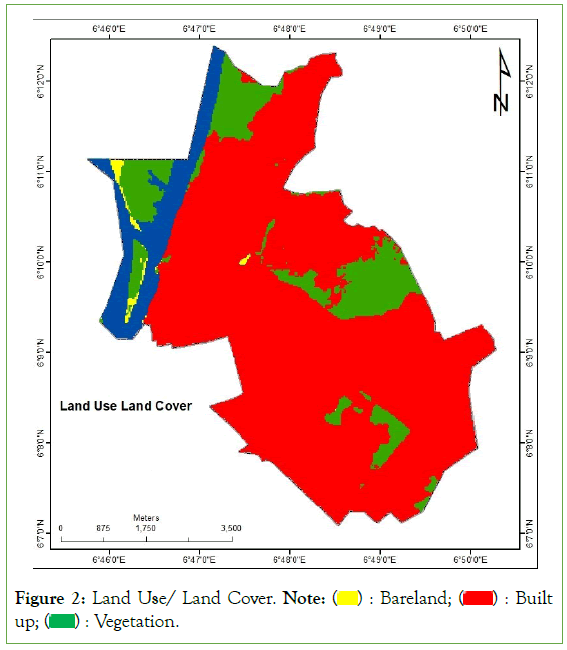
Figure 2: Land Use/ Land Cover. Note:  Built up;
  Vegetation.
| S/N | Classes | Description |
|---|---|---|
| 1 | Built-up area | Residential commercial, industrial and healthcare facilities |
| 2 | Bare land | Exposed soils, and areas of active excavation and production |
| 3 | Vegetation | Any species of plants (flora), forest |
| 4 | Waterbody | River, lakes and reservoirs |
Table 2: Land Use Land Cover (LULC) Classification Scheme.
WTE suitability map: The GIS and AHP were combined in order to determine the suitable sites for WTE facility in the study area. Five criteria (Land use/Land cover, distance from road, distance from surface water, distance from existing dumpsite and slope) (Figure 2). These criteria were considered because they are particularly relevant for siting WTE in the study area as suggested by [29]. This is because site selecting for municipal solid waste incineration power plant is a multi-criteria decision and the underlying criteria vary from one geographical location to another [30].
The Euclidean distance tool in ArcGIS 10.8 was used to produce a distance surface of all the vector layers (distance from road, distance from surface water and distance from existing dumpsite) as shown in Figure 2. Based on the AHP, each criterion was ranked and given a suitability score from 1 to 9, where the degree of suitability increases from 1 to 9. This was based on experts’ judgement, local and international references. Then, the AHP was used to assign weights to each criterion based on experts’ judgement [31]. The map layers were reclassified and standardised maps were generated for all the factors (Figure 3); and their respective weights were used to generate the WTE suitability map of the study area using weighted overlay tool in ArcGIS 10.8. The WTE suitability map was classified into not suitable, less suitable, marginally suitable and moderately suitable. The WTE suitability map is illustrated in Table 3 and Figure 4.
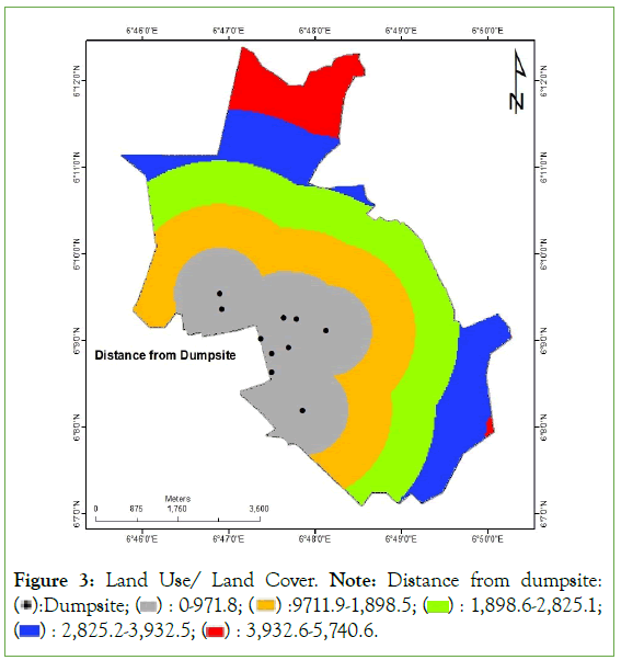
Figure 3: Land Use/ Land Cover. Note: Distance from dumpsite:  1,898.6-2,825.1;
  3,932.6-5,740.6.
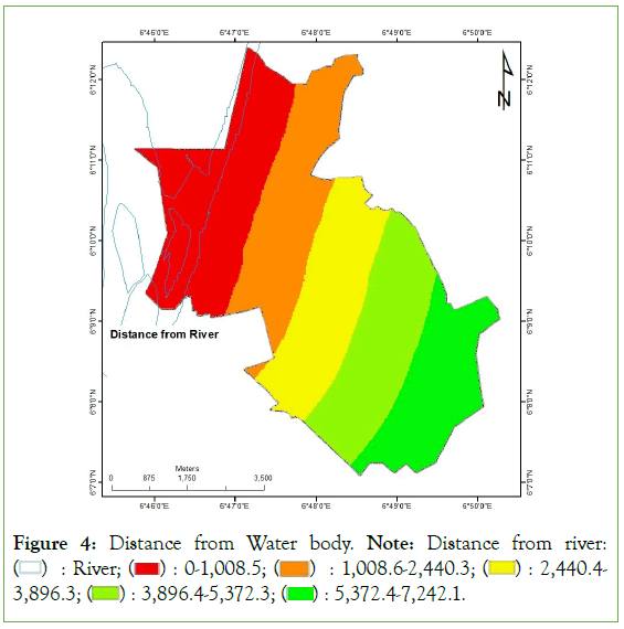
Figure 4: Distance from Water body. Note: Distance from river:  2,440.4-3,896.3;
  5,372.4-7,242.1.
| SN | Criterion | Category | Suitability | Ranking | Source |
|---|---|---|---|---|---|
| 1 | Land use land cover | Built up | Not suitable | 1 | [31] |
| Water | Not suitable | 1 | |||
| Vegetation | Marginally suitable | 5 | |||
| Bare land | Highly suitable | 9 | |||
| 2 | Distance from road (m) | 0-100, >1500 | Not suitable | 1 | [16] |
| 100-300 | Less suitable | 3 | |||
| 300-500 | Marginally suitable | 5 | |||
| 500-1000 | Moderately suitable | 7 | |||
| 1000-1500 | Highly suitable | 9 | |||
| 3 | Distance from surface Water (m) | 0-100 | Not suitable | 1 | [16] |
| 100-200 | Less suitable | 3 | |||
| 200-400 | Marginally suitable | 5 | |||
| 400-600 | Moderately suitable | 7 | |||
| >600 | Highly suitable | 9 | |||
| 4 | Distance from existing dumpsite (m) | 0-100 | Highly suitable | 9 | [32] |
| 100-300 | Moderately suitable | 7 | |||
| 300-500 | Marginally suitable | 5 | |||
| 500-700 | Less suitable | 3 | |||
| >700 | Not suitable | 1 | |||
| 5 | Slope (Degree) | 0-5 | Highly suitable | 9 | [33] |
| 05-Oct | Moderately suitable | 7 | |||
| Oct-15 | Marginally suitable | 5 | |||
| >15 | Less suitable | 3 |
Table 3: Criteria for siting WTE Facility in Onitsha North.
Results and Discussion
Mapping of suitability criteria for siting WTE facility
Site suitability analysis for WTE facility starts with identifying and mapping relevant criteria in the study area. In this case, five criteria which are land use/land cover, distance from dumpsite, distance from waterbody, distance from road and slope were mapped as shown in Figures 2-6. Mapping these criteria is very vital because each type of MSW treatment plant has its own specifications and, hence requires considering the particular appropriate criteria which vary from one geographical location to another [15]. Asserted that the choice of the most appropriate WTE technology to be adopted in a given area or region depends on the local specific conditions [9]. Therefore, before establishing a WTE plant like incinerator, a region-specific study is required to determine the most suitable site [18]. The first stage in determining the most suitable site is mapping the criteria for siting the WTE. The second stage is weighting the criteria to determine the relative influence of the criteria which is presented in the following section (Figure 2-Figure 6).
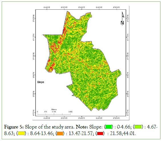
Figure 5: Slope of the study area. Note: Slope:  4.67-8.63;
  21.58;44.01.
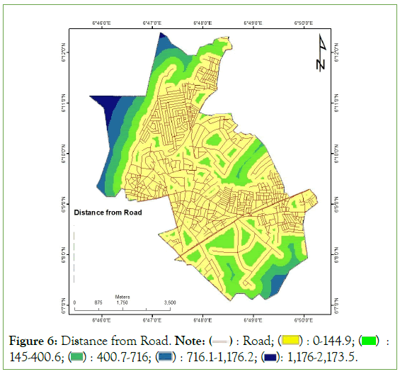
Figure 6: Distance from Road. Note:  145-400.6;
  1,176-2,173.5.
Weighting of the criteria for siting WTE facility
The influence of the five criteria in siting of the WTE facility. The pairwise comparison matrix is shown in Table 4. According to the findings in distance to existing MSW dumpsite has the highest weight of 0.26, followed by land use/land cover and distance to waterbody with weights of 0.24 and 0.23 respectively. Distance to road has weight of 0.17 while slope has the lowest weight of 0.10. Proximity to existing dumpsites is an essential criterion in siting WTE facility, because, in order to maintain constant operation of the facility there is the need for steady supply of waste at least transport cost.
| Factor | LULC | EMSW | WB | SL | RD |
|---|---|---|---|---|---|
| Land Use Land Cover (LULC) | 1 | 07-Sep | 07-Jun | 07-Mar | 07-May |
| Existing Municipal Solid Waste (EMSW) | 09-Jul | 1 | 02-Mar | 3 | 09-May |
| Waterbody (WB) | 06-Jul | 02-Mar | 1 | 2 | 06-May |
| Slope (SL) | 03-Jul | 01-Mar | 01-Feb | 1 | 03-May |
| Road (RD) | 05-Jul | 05-Sep | 05-Jun | 05-Mar | 1 |
Table 4: Pairwise matrix for MSW dumpsite criteria.
The findings of this study which showed that proximity to MSW dumpsite and land use/land cover are the most influential factors in siting WTE facility is based on geographic criteria. Reported that landuse/landcover was found to be the most influential factor in WTE facility siting while slope was the least influential factor [32]. Conversely, reported that the distance to river was the most important factor in determining a suitable landfill location for energy generation in Jabodetabek Area of Indonesia [33]. However, found that based on economic/technical and socio-cultural criteria, potential sites for locating WTE facilities in Lome of Togo are more influenced by slope and residence criteria [34]. It is observed from these studies that the relative influence of criteria for siting WTE facility varies from one location to another. These studies confirm the assertion that site suitability analysis for waste management system is location specific and should therefore take into account the specific environmental factors of the area under consideration. The suitability analysis of individual criteria is presented in the following section (Tables 4 and 5).
| Factor | LULC | EMSW | WB | SL | RD | Weight |
|---|---|---|---|---|---|---|
| Land Use Land Cover (LULC) | 0.233 | 0.187 | 0.28 | 0.233 | 0.233 | 0.23 |
| Existing Municipal Solid Waste (EMSW) | 0.3 | 0.24 | 0.16 | 0.3 | 0.3 | 0.26 |
| Waterbody (WB) | 0.2 | 0.36 | 0.24 | 0.2 | 0.2 | 0.24 |
| Slope (SL) | 0.1 | 0.08 | 0.12 | 0.1 | 0.1 | 0.1 |
| Road (RD) | 0.167 | 0.133 | 0.2 | 0.167 | 0.167 | 0.17 |
| Total | 1 | 1 | 1 | 1 | 1 | 1 |
Table 5: Normalised pairwise matrix for MSW dumpsite criteria.
Suitability analysis of the criteria
Suitability analysis of Land Use/Land Cover (LULC): Several factors are taken into account before identifying suitable sites for WTE plant or facility in order to protect the environment and safeguard human health. LULC is one of the critical factors taken into account in determining suitable sites for WTE plant or facility. Figure 7 and Table 6, show that the LULC in the study area comprises of built-up, water, vegetation and bareland. It can be seen from Table 6, that 85% of the LULC which comprises of built up and water is not suitable for WTE facility, while only 0.61% which constitute the bareland is highly suitable. This is because siting WTE facility has the potential to cause noise pollution in residential areas and thermal pollution which can affect water quality and harm the aquatics. However, vegetation is marginally suitable, agricultural lands, grasslands, and forest zones are examples of productive land areas that should be avoided when siting WTE facility [35]. Stressed that in order to mitigate the adverse impact such as odour, noise and emissions, power plants should be sited at longer distance from sensitive land uses (Table 6 and Figures 7-11) [10].

Figure 7: Reclassified land use land cover map. Note:  Not suitable;
  Highly suitable.
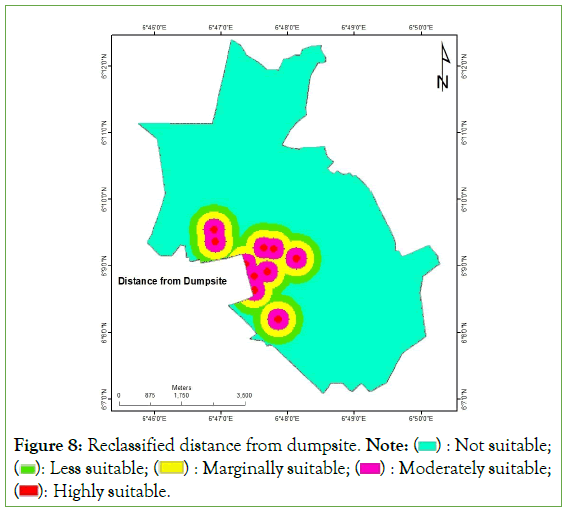
Figure 8: Reclassified distance from dumpsite. Note:  Not suitable;
  Moderately suitable;
  Highly suitable.
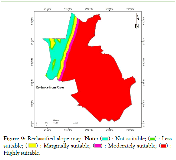
Figure 9: Reclassified slope map. Note:  Less suitable;
  Highly suitable.
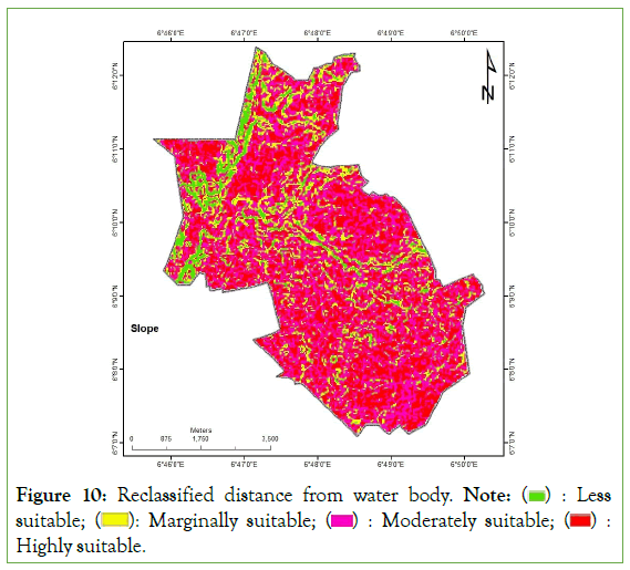
Figure 10: Reclassified distance from water body. Note:  Less suitable;
  Highly suitable.
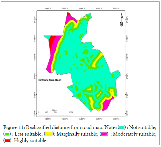
Figure 11: Reclassified distance from road map. Note:  Not suitable;
  Moderately suitable;
  Highly suitable.
| SN | Criterion | Category | Suitability | Ranking | Area (Ha) | % |
|---|---|---|---|---|---|---|
| 1 | Land use Land cover | Bare land | Highly suitable | 9 | 24.21 | 0.61 |
| Vegetation | Marginally suitable | 5 | 551.61 | 13.82 | ||
| Built up, Water | Not suitable | 1 | 3415.32 | 85.57 | ||
| Total | 3991.14 | 100 | ||||
| 2 | Distance from road (m) | 1000-1500 | Highly suitable | 9 | 67.77 | 1.7 |
| 500-1000 | Moderately suitable | 7 | 288.99 | 7.24 | ||
| 300-500 | Marginally suitable | 5 | 306.36 | 7.68 | ||
| 100-300 | Less suitable | 3 | 838.35 | 21.01 | ||
| 0-100, >1500 | Not suitable | 1 | 2489.67 | 62.38 | ||
| Total | 3991.14 | 100 | ||||
| 3 | Distance from waterbody (m) | >600 | Highly suitable | 9 | 3204.81 | 80.3 |
| 400-600 | Moderately suitable | 7 | 119.43 | 2.99 | ||
| 200-400 | Marginally suitable | 5 | 146.25 | 3.66 | ||
| 100-200 | Less suitable | 3 | 103.95 | 2.6 | ||
| 0-100 | Not suitable | 1 | 416.7 | 10.44 | ||
| Total | 3991.14 | 100 | ||||
| 4 | Distance from existing dumpsite (m) | 0-100 | Highly suitable | 9 | 31.5 | 0.79 |
| 100-300 | Moderately suitable | 7 | 185.94 | 4.66 | ||
| 300-500 | Marginally suitable | 5 | 244.62 | 6.13 | ||
| 500-700 | Less suitable | 3 | 242.01 | 6.06 | ||
| >700 | Not suitable | 1 | 3287.07 | 82.36 | ||
| Total | 3991.14 | 100 | ||||
| 5 | Slope (Degree) | 0-5 | Highly suitable | 9 | 1482.21 | 37.14 |
| 05-Oct | Moderately suitable | 7 | 1651.5 | 41.38 | ||
| Oct-15 | Marginally suitable | 5 | 600.66 | 15.05 | ||
| >15 | Less suitable | 3 | 256.77 | 6.43 | ||
| Total | 3991.14 | 100 |
Table 6: Suitability analysis for siting WTE facility.
Suitability analysis of distance from MSW dumpsite: Onitsha North is located in Anambra State with huge WTE potentials of 91-139 MW based on MSW generation of 0.53 kg/cap/day –0.80 kg/cap/day [5]. These huge WTE potentials can be maximally exploited using the proper technology and adhering to proper siting criteria. Proximity to existing dumpsite is an essential factor to be considered in siting WTE plant. This is in order to reduce the environmental, economic and social costs of transporting the wastes to the plant. WTE plants are ideally situated within or close to dumpsites in order to cut down transportation costs [10,36]. Therefore, the distance from existing landfills is a crucial factor to be considered when locating waste conversion facilities [37]. This is particularly essential in a country like Nigeria, where waste collections are not well organised and that contributes to high solid waste collection cost [38]. Figure 7 and Table 6, shows that locations greater than 700 meters from dumpsites are not suitable for WTE facility, highly suitable locations are found between 0 meters and 100 meters. Other categories of suitability based on distance from MSW dumpsite can be seen in Table 6. It can be observed from the Table that on basis of this criterion, 82% of the area is not suitable while only about 0.8% is suitable for WTE facility. This is due to the urbanised nature of the study area which does not support siting of WTE close to residential and commercial centres in the area. In siting waste energy recovery system, the distance from the settlement was found to be the highest priority in determining the landfills for energy generation, based on the environmental criteria [39].
Suitability analysis of slope: A flat area is more suitable for a waste management facility in order to reduce the risks associated with soil water quality, erosion, and surface runoff [40]. Figure 9 and Table 6, reveal that locations with slope angle greater than 15 degrees are not suitable for WTE while those found on gentle slopes with values ranging from 0 to 5 degrees are highly suitable for WTE plants. This is supported by [41], who proposed that areas characterised with slope of 0-5° are highly suitable as against areas with slope of>15° that are not suitable. On the basis of this criterion, about 37% of the area with slope angle 0-<5 degrees is highly suitable and 41% with slope angle of 5 ≤ 10 degrees is moderately suitable for siting WTE facility. But, 15% of the study area (with slope of 10-15°) and 6% (with slope>15°) are marginally and less suitable respectively [42]. Asserted that areas with slope of 0-5, 5–10 average and 10–45 are categorised as high, average and low respectively in terms of suitability for WTE plant.
Suitability analysis of distance from water body: Certain distance should be set apart from the WTE plant in order to reduce the various effects of pollutants associated with the plant operations on the natural environment [43]. Distance from water body is a significant criterion in siting WTE facilities to prevent pollution and contamination of water body [44]. Figure 10 and Table 6, reveal that locations at a distance of ≤ 600 meters from water body (rivers and streams) are highly suitable while those locations at a distance of ≤ 100 meters from water body are not suitable for WTE facility. Based on this, it is observed from Table 6, that about 80% of the study area is highly suitable and 10% is not suitable for siting WTE plant. It is important that WTE facilities should be sited far from water body in order to avoid water pollution which is detrimental to humans and aquatics.
Suitability analysis of distance from road: The proximity to a transportation network is an important factor to be considered when selecting a site for WTE plant. Because, distance to road will affect production cost resulting from higher cost of waste transportation and access to transmission lines; that is the reason why WTE facility should not be far from road [15]. Therefore, the site of solid waste incineration power plant is preferable to be close to main roads [10]. Figure 11 and Table 6, show that locations at a distance of 1000 meters-1500 meters from road are highly suitable while those locations at a distance of 0 meters-100 meters and>1500 meters from road are not suitable for WTE facility. On the basis of this, 1.70%, 7.0% and 52% are highly suitable, moderately suitable and not suitable respectively for siting WTE plant.
Suitability map for WTE facility in Onitsha north LGA: The suitability of all the considered factors was integrated to produce a suitability map for WTE in Onitsha North LGA as shown in Figure 12. Siting of WTE facilities in an urbanised and commercial centre like the study area is required in order to provide alternative and sustainable energy source to boost the energy supply mix for industrial, commercial and household activities in the city. Based on the results of this study as presented in Table 7, only 0.97% of the study area is moderately suitable, while 77% is marginally suitable, and 21% of the study area is less suitable for siting WTE facility (Table 7).
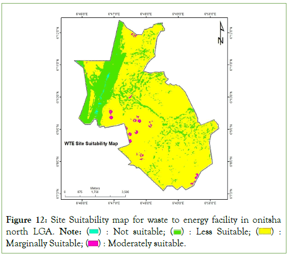
Figure 12: Site Suitability map for waste to energy facility in onitsha north LGA. Note:  Marginally Suitable;
  Moderately suitable.
| Suitability | Ranking | Area (Ha) | % |
|---|---|---|---|
| Moderately suitable | 7 | 38.79 | 0.97 |
| Marginally Suitable | 5 | 3085.02 | 77.3 |
| Less suitable | 3 | 854.28 | 21.4 |
| Not suitable | 1 | 13.05 | 0.33 |
| Total | 3991.14 | 100 |
Table 7: Suitability analysis for siting WTE facility.
In a similar study carried out by in a different geographical location, their results showed that 2.8 % of Jos metropolis in north central Nigeria exhibited high suitability for siting a WTE facility, while 41.7 % and 21% are moderately suitable and suitable respectively [34]. Produced a suitability map for siting WTE plant in Alexandria governorate of Egypt [18]. The map indicated that only 2 % of the land is suitable for siting an incineration plant in the study area. These studies on WTE facility siting produced different outcomes in different geographical location, which is another justification that suitability analysis is required for siting WTE in any given geographical area or region.
The classification into different levels of suitability for siting waste to energy facility as shown in Table 7, is based on the integration of several factors in order to mitigate the environmental and health impacts of the operation of the WTE plant. The integration of these factors especially in an urban area like Onitsha North is the reason why the area is not highly suitable but there are areas of moderate and marginal suitability that can be considered for siting WTE facility. However, consideration of these criteria is very vital because they influence operations of the facility in the longterm. Hence, it is essential to integrate the environmental impact assessment in the pre-project stage of a MSW incineration plant, rather than at its project stage, in order to make it environmentally sustainable and socially acceptable in an area or region [15].
Reported that about 25, 6, and 2 small-scale, medium-scale and large-scale WTE plants respectively can be installed in Onitsha North [20]. But the study has not provided the suitable sites for locating the various categories of WTE plants which ranges from small to large-scale. The present study has highlighted the suitable locations for siting WTE plants in Onitsha North as shown in Figure 12. However, even in the areas of moderate and marginal suitability in the study area [8], reported that anaerobic digestion was found to be the most viable WTE technology that can be adopted as is the case in the southern region of Nigeria. However, comparative and critical analyses of the various WTE technology options should be done at any point in time before installing the required technology in order to achieve maximum benefits of WTE implementation (Figure 12).
In spite of the huge energy potentials of waste in Nigeria, there are numerous challenges with the waste management system in the country. The challenges include solid waste disposed in open dumps, lack of proper documentation of waste generation rates or the composition of the wastes, inefficient methods of waste collection and storage as well as lack of separation of waste [6]. Another waste management problem in developing nations that should be addressed is poor waste management planning [44]. Other challenges are lack of regulatory framework, infrastructure and management of end-products of recycling processes, as well as lack of investment and technology for WTE [7]. These challenges need to be addressed in order to achieve successful implementation of WTE technology in Onitsha North and other cities across Nigeria.
Conclusion
This study combined GIS and MCDA to identify suitable sites for WTE facility in Onitsha North. The AHP was used to assign weights to the relevant factors that influence site suitability of WTE facility. The factors were combined using weighted overlay to produce WTE suitability map. Less than 1% and 77% of the study area were found be moderately suitable and marginally suitable respectively for siting WTE plant. The study has provided basic information required to harness the energy potentials of waste for sustainable development in the area. These waste energy potentials can be exploited to provide alternative energy source for industrialisation and economic activities in the area. The results of this study confirm the assertion that site suitability analysis for waste management system is location specific and should therefore take into account the specific environmental factors of the area under consideration. This is another justification that suitability analysis is required for siting WTE in any given geographical area or region. The combination of GIS and MCDA has proven to be efficient in site suitability analysis; hence it can be applied in addressing multi-criteria decision problems.
Data Availability
The datasets used and/or analysed during the current study available from the corresponding author on reasonable request.
Conflict of Interest
The author has declared no conflict of interest.
References
- Ajaero CC, Okafor CC, Otunomo FA, Nduji NN, Adedapo JA. Energy production potential of Organic Fraction Of Municipal Solid Waste (OFMSW) and its implications for Nigeria. Clean Technol Recycl. 2023;3(1):44-65.
- Nubi O, Morse S, Murphy RJ. Electricity generation from municipal solid waste in Nigeria: A Prospective LCA Study. Sustainability. 2022;14(15):9252.
- Sowunmi AA. Municipal solid waste management and the inland water bodies: Nigerian perspectives. Municipal Solid Waste Management. 2019:141.
- Akhator EP, Obanor AI, Ezemonye LI. Electricity generation in Nigeria from municipal solid waste using the Swedish Wasteto-Energy Model. J Appl Sci Environ Manag. 2016;20(3):635-43.
- Somorin TO, Adesola S, Kolawole A. State-level assessment of the waste-to-energy potential (via incineration) of municipal solid wastes in Nigeria. J Clean Prod. 2017;164:804-815.
- Yusuf RO, Adeniran JA, Mustapha SI, Sonibare JA. Energy recovery from municipal solid waste in Nigeria and its economic and environmental implications. Environ Qual Manag. 2019;28(3):33-43.
- Okafor CC, Nzekwe CA, Nduji NN, Ajaero CC, Ibekwe JC. Energy and material recovery potential from Municipal Solid Wastes (MSW) in Nigeria: Challenges and opportunities. Clean Technol Recycl. 2022;2(4):282-307.
- Ogunjuyigbe AS, Ayodele TR, Alao MA. Electricity generation from municipal solid waste in some selected cities of Nigeria: An assessment of feasibility, potential and technologies. Renew Sust Energ Rev. 2017;80:149-162.
- Scarlat N, Motola V, Dallemand JF, Monforti-Ferrario F, Mofor L. Evaluation of energy potential of municipal solid waste from African urban areas. Renew Sust Energ Rev. 2015;50:1269-1286.
- Hassaan MA. A GIS-based suitability analysis for siting a solid waste incineration power plant in an urban area case study: Alexandria governorate, Egypt. J Geogr Inf Syst. 2015;7(06):643.
- Isma'il M. Site suitability analysis for waste to energy facility in Onitsha north local government Area, Anambra State, Nigeria. 2023.
- Ranade P, Bapat G. Estimation of power generation from solid waste generated in sub urban area using spatial techniques: A case study for Pune City, India. Int J Geomat Geosci. 2011;2(1):179-187.
- Tan ST, Hashim H, Lee CT, Lim JS, Kanniah KD. Optimal waste-to-energy strategy assisted by GIS for sustainable solid waste management. IOP Conf Ser Earth Environ Sci. 2014;18(1):012159.
- Dodo UA, Ashigwuike EC. In-depth physico-chemical characterization and estimation of the grid power potential of municipal solid wastes in Abuja city. Energy Nexus. 2023;10:100192.
- Wu Y, Qin L, Xu C, Ji S. Site selection of waste-to-energy (WTE) plant considering public satisfaction by an extended VIKOR method. Math Probl Eng. 2018:1-7.
- Tavares G, Zsigraiová Z, Semiao V. Multi-criteria GIS-based siting of an incineration plant for municipal solid waste. Waste Manage. 2011;31(9-10):1960-1972.
- Akther A. Site suitability assessments for waste management using GIS and multi-criteria analysis: Potentials of waste to energy and urban agriculture. 2017.
- Yalcinkaya S, Kirtiloglu OS. Application of a geographic information system-based fuzzy analytic hierarchy process model to locate potential municipal solid waste incineration plant sites: A case study of Izmir Metropolitan Municipality. Waste Manag Res. 2021;39(1):174-184.
- Abushammala MF, Qazi WA, Frrag S, Alazaiza MY, Younes MK. Site selection of municipal solid waste incineration plant using GIS and multi-criteria decision analysis. J Air Waste Manag Assoc. 2022;72(9):1027-1039.
- Unaegbu EU, Baker K. Assessing the potential for energy from waste plants to tackle energy poverty and earn carbon credits for Nigeria. Int J Energy Technol Policy Magn. 2019;4(2):8-16.
- Chukwuma EC, Ojediran JO, Anizoba DC, Ubah JI, Nwachukwu CP. Geospatially based analysis and economic feasibility evaluation of waste to energy facilities: A case study of local government areas of Anambra State of Nigeria. Biomass Convers Biorefin. 2021;24:1-2.
- Mshelia RB, Diso IS, Adamu AA. Technical and economic analysis of energy recovery from municipal solid waste in Yola metropolis, Adamawa State, Nigeria. Hittite J Sci Eng. 2022;9(2):117-123.
- Ibikunle RA. Exploration and prediction of wet season municipal solid waste for power generation in Ilorin metropolis, Nigeria. J Mater Cycles Waste Manag. 2022;24(4):1591-1602.
- Ondachi PA, Ozigis II, Zarmai MT. Determination of electric power generation potential of Abuja’s municipal solid wastes. Niger J Technol. 2023;42(1):114-121.
- Okonkwo A. An effective solid waste management system in Awka, Anambra State, Nigeria: A proffered solution of a well-articulated plan of attributes. Waste Mgt Environ. 2014;2:293-301.
- Obi PI, Okonkwo II, Ogba CO. Power supply enhancement in Onitsha distribution network using distribution generations. Niger J Technol. 2022;41(2):318-329.
- Orobi FI, Isma’il M. Site suitability analysis for municipal solid waste dumpsites in Onitsha north local government area, Anambra State, Nigeria. Int J Disaster Risk Reduct. 2022;1(2):260-272.
- Birkie A, Addisu S, Mekuriaw A. Solid waste management practice and dumpsite suitability analysis using GIS technology in Debre Markos town, Ethiopia. Ethiop J Sci Technol. 2020;13(2):115-130.
- Chukwuma EC, Okey-Onyesolu FC, Ani KA, Nwanna EC. GIS bio-waste assessment and suitability analysis for biogas power plant: A case study of Anambra state of Nigeria. Renew Energ. 2021;163:1182-1194.
- Saaty TL. Decision making with the analytic hierarchy process. Int J Serv Sci. 2008;1(1):83-98.
- Ebistu TA, Minale AS. Solid waste dumping site suitability analysis using Geographic Information System (GIS) and remote sensing for Bahir Dar Town, North Western Ethiopia. Afr J Environ. 2013;7(11):976-989.
- Noorollahi E, Fadai D, Akbarpour Shirazi M, Ghodsipour SH. Land suitability analysis for solar farms exploitation using GIS and Fuzzy Analytic Hierarchy Process (FAHP)—A case study of Iran. Energies. 2016;9(8):643.
- Khan MM, Vaezi M, Kumar A. Optimal siting of solid waste-to-value-added facilities through a GIS-based assessment. Sci Total Environ. 2018;610:1065-1075.
- Kabite G, Suryabhagavan KV, Argaw M, Sulaiman H. GIS-based solid waste landfill site selection in Addis Ababa, Ethiopia. Int J Ecol Environ. Sci. 2012;38(2-3):59-72.
- Isma'il M. Site suitability analysis for waste to energy facility in Onitsha north local government area, Anambra State, Nigeria. 2023.
- Nanda MA, Wijayanto AK, Imantho H, Nelwan LO, Budiastra IW, Seminar KB. Factors determining suitable landfill sites for energy generation from municipal solid waste: A Case Study of Jabodetabek Area, Indonesia. The Scientific World Journal. 2022.
- Jensen, L. A Cairo tradition takes on a new track. Turning Trash into cash. 1990.
- Panepinto D, Zanetti MC. Municipal solid waste incineration plant: A multi-step approach to the evaluation of an energy-recovery configuration. Waste Manage. 2018;73:332-341.
- Sambiani K, Lare Y, Zanguina A, Narra S. Location-allocation combining fuzzy analytical hierarchy process for waste to energy facilities siting in developing urban areas: The case study of Lomé, Togo. Heliyon. 2023;9(9) e19767.
- Asefa EM, Damtew YT, Barasa KB. Landfill site selection using GIS based multi-criteria evaluation technique in Harar City, Eastern Ethiopia. Environ Health Insights. 2021;15:11786302211053174.
- Hu H, Li X, Nguyen AD, Kavan P. A critical evaluation of waste incineration plants in Wuhan (China) based on site selection, environmental influence, public health and public participation. Int J Environ Res Public Health. 2015;12(7):7593-614.
- Olukanni DO, Adeleke JO, Aremu DD. A review of local factors affecting solid waste collection in Nigeria. 2016.
- Isma’il M, Abbas S, Ibrahim MY, Naibbi AI. Site suitability analysis for waste to energy plant in Kaduna metropolis, Nigeria. J Mater Cycles Waste Manag. 2023;12:1-3.
- Jaisue N, Ketjoy N, Kaewpanha M, Thanarak P. The barriers analysis for waste-to-energy project development in Thailand: Using an interpretive structural modeling approach. Energies. 2023;16(4):1941.
Citation: Isma’il M (2024) Site Suitability Analysis for Waste to Energy Facility in Onitsha North Local Government Area, Anambra State, Nigeria. J Remote Sens GIS. 13:329.
Copyright: © 2024 Isma’il M. This is an open access article distributed under the terms of the Creative Commons Attribution License, which permits unrestricted use, distribution, and reproduction in any medium, provided the original author and source are credited.

