Indexed In
- SafetyLit
- RefSeek
- Hamdard University
- EBSCO A-Z
- OCLC- WorldCat
- Publons
Useful Links
Share This Page
Journal Flyer

Open Access Journals
- Agri and Aquaculture
- Biochemistry
- Bioinformatics & Systems Biology
- Business & Management
- Chemistry
- Clinical Sciences
- Engineering
- Food & Nutrition
- General Science
- Genetics & Molecular Biology
- Immunology & Microbiology
- Medical Sciences
- Neuroscience & Psychology
- Nursing & Health Care
- Pharmaceutical Sciences
Research Article - (2019) Volume 22, Issue 1
Sea Dykes as a Coastal Protection Strategy: Effectiveness and Constraints in Kien Giang, Vietnam
Thai Thanh Luom*Received: 10-Feb-2019 Published: 26-Feb-2019
Abstract
Muddy coasts have been extensively used for socio-development. The consequence was that these coasts have been threatened by natural and anthropogenic factors. Sea dykes were considered as an effective solution to protect muddy coasts and to adapt to climate change and sea level rise. Kien Giang mangrove dominated muddy coast was severely eroded and vulnerable to erosion. Sea dykes were constructed along the Kien Giang coast to as an effective strategy for protecting the Kien Giang coast. However, the Kien Giang coast was severely eroded, with aquaculture ponds eroded and mangroves uprooted. This study aims to critically review the effectiveness of the sea dykes in terms of coastal protection. The sea dyke system has been limited success, with the Kien Giang coastline made vulnerable to erosion and uprooting of Rhizophora species and aquaculture ponds vulnerable to erosion. The construction and upgrading of the sea dyke system significantly contribute to the vulnerability to erosion. The majority of the local farmers recognized the importance of mangrove protection and sea dykes in adaptation to climate change and sea level rise. However, there was still a small percentage of local community members who did not need sea dykes to protect their properties. Saline water was considered as alternative management option for livelihood improvement.
Keywords
Aquaculture Ponds; Kien Giang; Mekong Delta; Muddy Coasts; Sea DykesIntroduction
The world’s coastlines have many economically and environmentally valuable resources including land, forests, coastal waters and wetlands, sand, minerals, hydrocarbons, and living marine organisms [1]. The location of these valuable coastal resources has always attracted human settlement. Along or within 200 km of a coastline, about 10 percent of the Earth’s land area has been occupied by approximately 3.2 billion people [2]. Muddy coasts, where mangroves dominate, have been used for creating large areas of new land for agriculture, aquaculture, industry, and settlements [3]. This use has caused adverse direct and indirect impacts on muddy coasts. The morpho-dynamics of muddy coasts can be impacted by storm surges and typhoons during high tides and strong onshore winds and their accompanying onshore storm surge effect [4].
According to the Intergovernmental Panel on Climate Change [5-8]. Muddy coasts are vulnerable to climate change, particularly the effects of sea level rise. Sea level rise may cause coastal inundation and erosion, possibly resulting in millions of climate change refugees [2]. In addition to negative impacts of sea level rise, human activities such as tourism, aquaculture and fisheries have worsened some of the problems, particularly erosion [2].
In response to coastal erosion, climate change, sea level rise and coast related hazards, engineered solutions and ecological engineered solutions have been employed. The engineered solutions include shoreline structures and offshore or detached structures [9]. Such as seawalls, revetments, and bulkheads, groynes, groyne fields (a series of groynes), and jetties or breakwaters [9]. Ecological engineered solutions include mangrove planting or a combination of mangrove planting and engineered solutions [10-12].
Kien Giang coast is classified as a muddy coast dominated by mangrove species in accordance to the definition confined by Wang et al. [3]. In 2009, 30% of the total 208 km coastline of Kien Giang was reported as being severely eroded (Conservation and Development of the Kien Giang Biosphere Reserve Conservation Project) [13,14]. There was a rise in sea level at an annual rate of approximately 3 mm between 1993 and 2008 in Vietnam [15]. Sea level has been projected to increase by at least 65 cm by the next 100 years in the Mekong Delta region [16] and the effects on Kien Giang will be severe (Kien Giang Provincial People’s Committee [17]. The government at all levels invested funds in constructing sea dykes in protecting the Kien Giang coast as an effective solution to coastal erosion and for adaptation to climate change and sea level rise [18]. The question is if the sea dykes and the mangrove belt are strong to protect the coast and to adapt to the projected climate change and sea level rise. This study aims to critically review the effectiveness of the sea dyke system in terms of coastal protection and livelihood improvement. The study involves stakeholders (local farmers and staff working for government agencies) who have been involved in managing and using mangroves and sea dykes.
Materials and Methods
Site description
Kien Giang province is located southwest of Ho Chi Minh City, 6 hour drive. Kien Giang province has a coastline of 208 km [13] that stretches over four coastal districts, one town and one city (Figure 1).
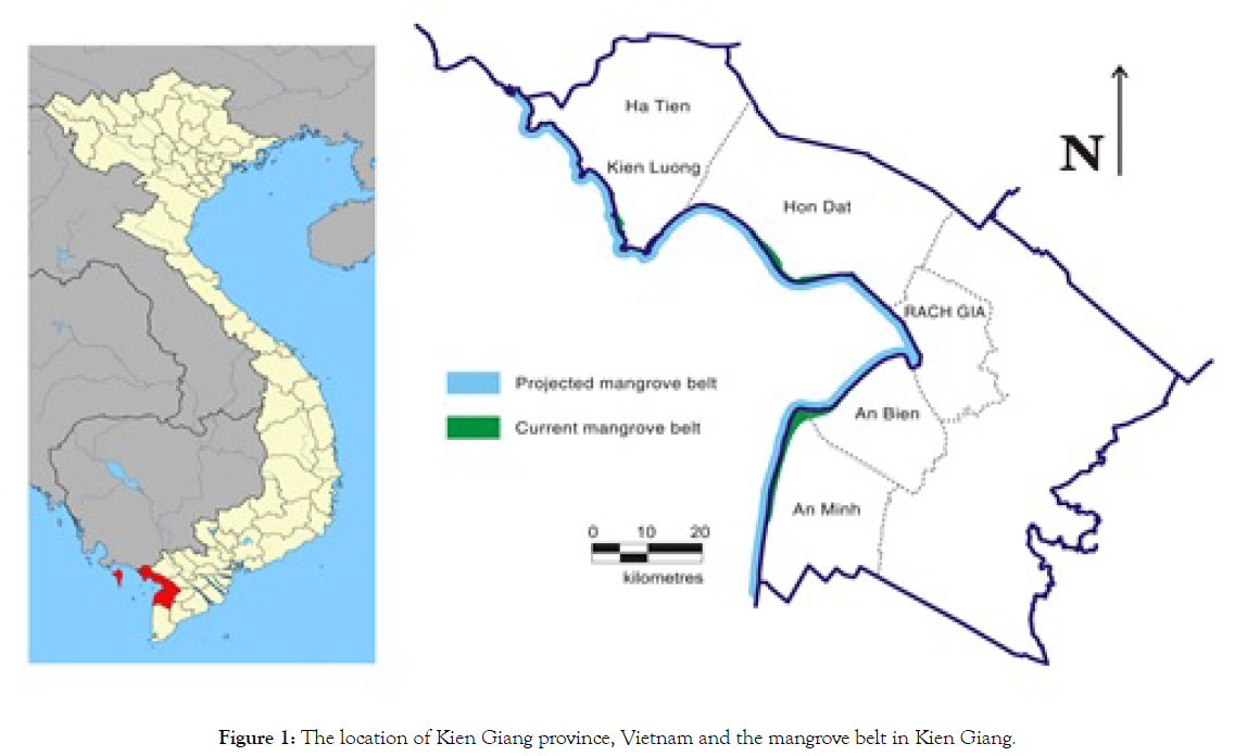
Figure 1: The location of Kien Giang province, Vietnam and the mangrove belt in Kien Giang.
The Kien Giang mangrove dominated muddy coast was established as mangrove protection forests in 2005 (Kien Giang Provincial People’s Committee [17]. 208 km of mangrove areas are currently protected as protected mangrove forest and managed by two Management Boards, Kien–Hai–Ha Management Board and the An Bien–An Minh Management Board. The two current Management Boards are under the direct management of the Kien Giang Department of Agriculture & Rural Development (DARD) [19]. There were 29 mangrove species present along the Kien Giang coastline [20]. The earth sea dykes, mangroves, intertidal mudflats and sea water areas in front of intertidal mudflats are integral parts of the Kien Giang coastline, but are managed by different governmental agencies. Sea water areas are managed by the district people’s committees and are used for aquaculture purposes [18]. The intertidal mudflats and mangrove areas are managed by the two Management Boards. The mangroves are classified as either being in the primary mangrove belt or the secondary mangrove belt.
The earth sea dyke system was first constructed in the 1970s along the entire coastline of Kien Giang province for irrigation and national defence purposes. Sluice gates were constructed across the natural rivers and channels to complete the sea dyke system. To date, 31 sluice gates have been built between Ha Tien and An Minh. A further 64 new sluice gates are proposed [18,21].
Methods
The study employed a various methods approach to achieve the objective of the study. The various methods approach included secondary data analysis, field visits and semi-structured interviews participatory community meetings and the use of MapInfo software [22].
Written reports, polices, and outputs from pilot programs related to land use planning, mangrove restoration, sea dyke construction and fisheries were obtained from government agencies (DARD, Department of Natural Resource & Environment, the An Bien– An Minh Management Board, the Kien–Hai–Ha Management Board, the District People’s Committee of An Bien, An Minh, Kien Luong and Hon Dat) and non-government agencies who have been implementing projects in Kien Giang province (IUCN, the Centre for Environmental Science of Hanoi National University). As a result, questions in relation to status of the Kien Giang coastline, the earth sea dyke system, local communities’ involvement and aspiration in coastal mangrove protection and management and aquaculture/agriculture was derived and used in semi-structure interviews and meetings with community members, particularly fishers/farmers.
Previous maps were collected and analyzed using the MapInfo software. The results were a base map developed as a basic information for subsequent field trips for validation. Visits along the Kien Giang coastline were undertaken with administrative assistance from DARD and the two Management Boards. The visits were undertaken using boats and small motorbikes. While emphasis was placed on erosion areas, almost the entire Kien Giang coastline was visited. During the field visits, the entire Kien Giang coastline was strategically assessed to view the vulnerability of coastal mangrove areas, as determined by the nature of coastal erosion to which they are exposed, the likelihood or frequency of occurrence of coastal erosion, the extent of erosion, and the sensitivity of the coastal areas to the impacts of the erosion.
Semi-structured interviews were conducted with village leaders. In the interviews, photographs previously taken in the areas were used to provide an overview of how sea dykes were constructed and what had happened in the area. As a result, issues related to the construction and use of the earth sea dykes, coastal protection were adequately recorded to provide an overview of coastal protection in Kien Giang. Local aspirations related to livelihood improvement were also recorded using the questionnaires.
A number of community meetings were held involving fishers and farmers in both eroding coastal and accreting coastal areas of Kien Giang province. During the meetings, the list of issues, photographs taken previously in the area, Google maps of the area, maps of forestry planning and inventory and maps of land use planning were used to promote involvement in discussions and sharing of local knowledge and lessons. This process provided further opportunity to confirm, to update/verify the information provided by the governments and scientific reports.
Data and information collected from secondary data analysis, were systematically recorded using networking and MapInfo software, resulting in a multi-dimensional summary that was used to promote subsequent, more intensive analysis. The multidimensional summary was used for discussion during field visits, semi-structured interviews and participatory community meetings. The answers and data collected from field visits, semi-structured interviews and participatory community meetings and the process of data collection were analyzed, collated and categorized into themes. The themes were validated by detailed minutes that were signed by participants, which are the main findings of this study.
Results
Sea dyke construction and upgrading
Sea dykes were upgraded or constructed to protect the coastline and to adapt to climate change and sea level rise. Sea dykes were upgraded clearing naturally regenerated mangroves and placing concrete blocks on top of loose surface ground. Sluice gates were constructed over man-made and natural channels to connect sea dykes. The construction of sluice gates also involved the clearance of mangroves on site. As a consequence, sea dykes and sluice gates were made vulnerable to erosion or exposed to the sea because there was not protection line of mangroves in front of these structures. In T5, T6 and Vam Ray areas of Hon Dat district, sea dykes were dug to create gaps to replace water pipes that were used for pumping sea water to aquaculture ponds (Figure 2).
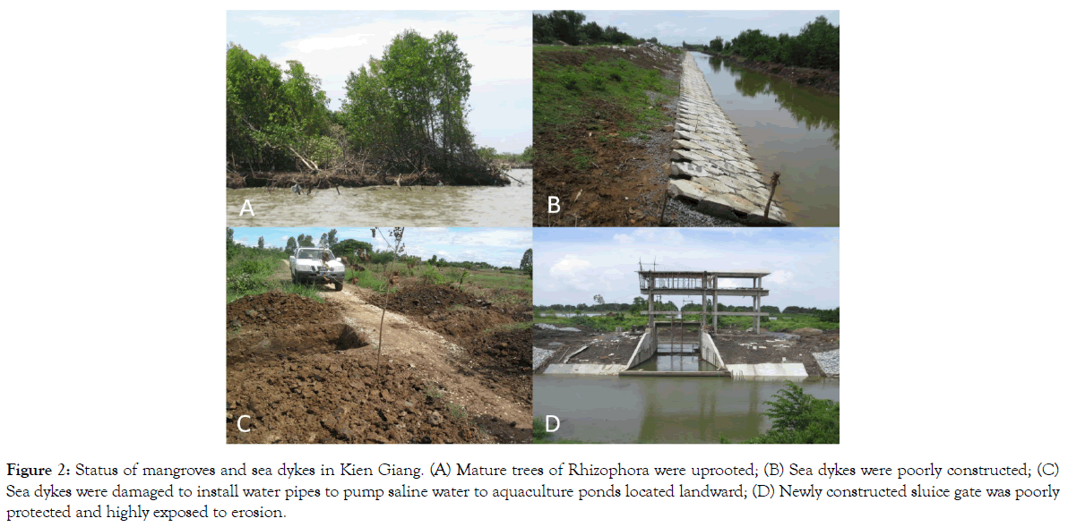
Figure 2: Status of mangroves and sea dykes in Kien Giang. (A) Mature trees of Rhizophora were uprooted; (B) Sea dykes were poorly constructed; (C) Sea dykes were damaged to install water pipes to pump saline water to aquaculture ponds located landward; (D) Newly constructed sluice gate was poorly protected and highly exposed to erosion.
The status of the Kien Giang coastline
Up to 2014, the Kien Giang coastline remained severely eroded, with remnants of pond dykes and pond gates found along the shoreline on low tides, the loss of mangrove vegetation, sea dykes breached, mangroves were degraded or deforested, especially with Rhizophora apiculata being uprooted. The coastline were dissected by ponds of all sizes and protected by a thin line of coastal mangroves, aquaculture ponds of all sizes exposed to the sea, and agriculture areas. (Figures 3 and 4, Table 1).
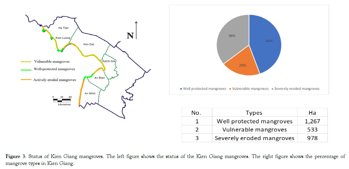
Figure 3: Status of Kien Giang mangroves. The left figure shows the status of the Kien Giang mangroves. The right figure shows the percentage of mangrove types in Kien Giang.
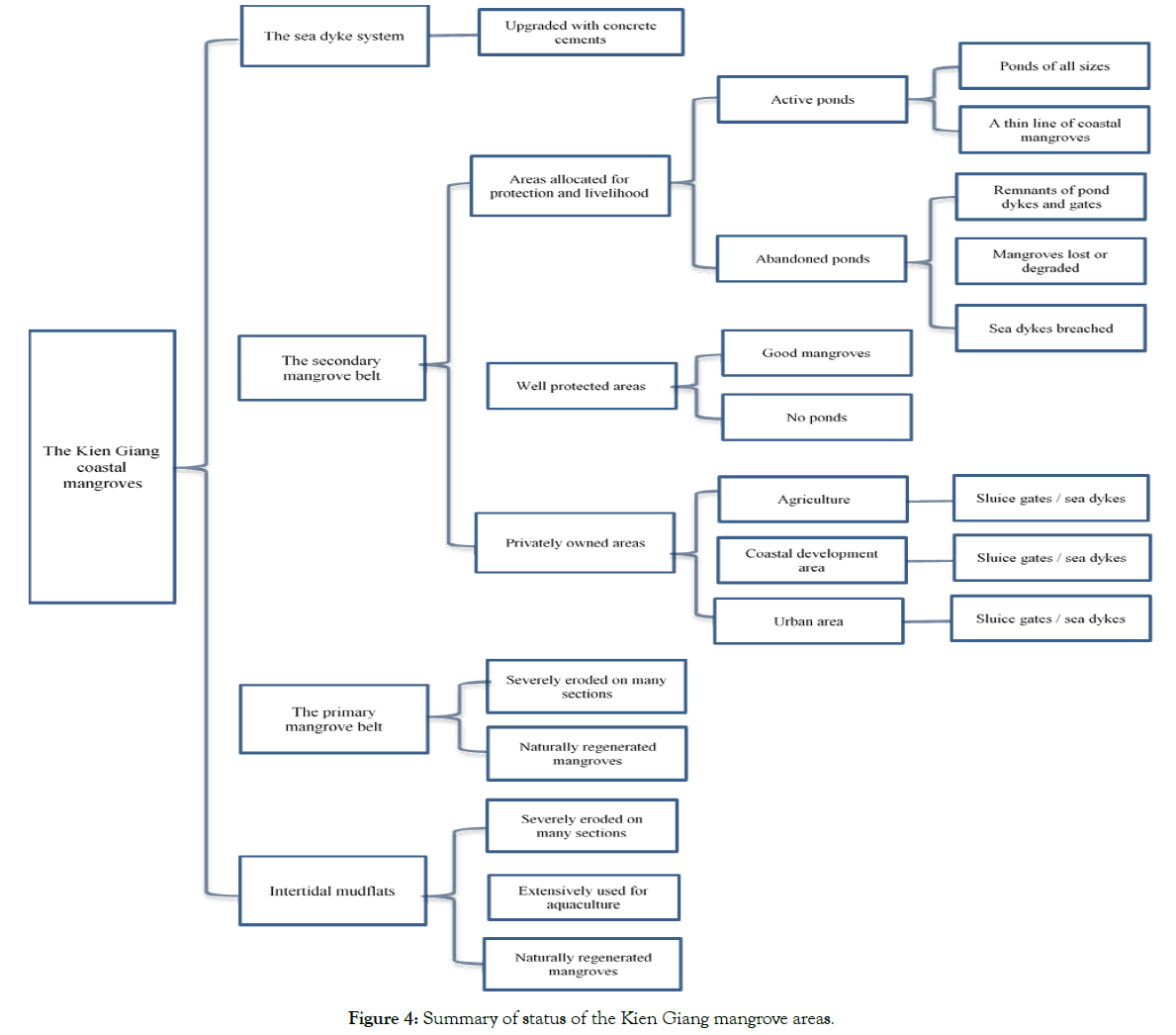
Figure 4: Summary of status of the Kien Giang mangrove areas.
Table 1: Status of aquaculture ponds and land ownership in Kien Giang.
| District | Commune | AMs | |
|---|---|---|---|
| With active ponds | With abandoned ponds | ||
| Kien Luong | Binh Tri | Yes | no |
| Hon Dat | T 5 | no | no |
| T 6 | no | no | |
| Vam Ray | no | yes | |
| An Bien | Nam Thai | yes | Yes |
| Nam Yen | yes | yes | |
| Tay Yen | yes | yes | |
| An Minh | Thuan Hoa | yes | yes |
| Dong Hung | yes | Yes | |
| Van Khanh | yes | yes | |
| Van Khanh Tay | yes | yes | |
Local perspectives of the function of the Kien Giang mangroves and sea dykes
Of 207 local farmers interviewed, 115 interviewees (about 56% of total farmers interviewed) strongly agreed that mangroves and sea dykes have been successful in protecting ponds and properties from erosion, especially under the influence of sea level rise or storm surges. 67 farmers (around 32%) disagreed that mangroves and sea dykes did not properly protect their ponds or properties from erosion. They believed that the mangrove transplantation and the construction of the sea dykes would protect them from erosion in the future, especially when sea level rise occur. 25 households (12%) neither disagreed nor agreed that the mangroves and sea dykes adequately protected their properties. They believe that it would be safe to stay far from the coast. They did not intend to construct houses among stands of mangroves or near the coast (Figure 5).
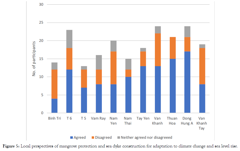
Figure 5: Local perspectives of mangrove protection and sea dyke construction for adaptation to climate change and sea level rise.
Local aspirations in relation to livelihood improvement
were unsure of the effectiveness of the sea dyke system said that they needed saline water for operating their ponds. Sea dykes stopped saline water entering their ponds. Agriculture was no long productive because total return gained from agriculture was not enough to support their families.
Discussion
The effectiveness of the sea dyke system
The current sea dyke system in Kien Giang primarily focuses on establishing and protecting individual coastal sections, especially severely eroded areas and through transplantation of mangroves on intertidal mudflats [23-26]. However, the sea dyke system has been limited success. Sea dyke upgrading and construction were believed to stop or even reserve erosion process for adaptation to climate change and sea level rise. The government agencies invested a significant funding in upgrading and constructing sea dykes and sluice gates. However, sea dykes were poorly upgraded or constructed, as shown in Figure 4. These structures were poorly protected with no protection line of mangroves seaward. If the same approaches do not change, sea dykes will be highly breached in periods of strong waves. Rhizophora apiculata, transplanted in the 1980s, were not able to protect the coast. Figure 4 shows that the sea dyke construction is not adequate to protect the Kien Giang coastline and especially to adapt to climate change and sea level rise.
The local use of the Kien Giang coastline
The Kien Giang coastline has been used for livelihood improvement. The use included mangrove allocation for livelihood improvement and pond operation. The use of mangroves for livelihood improvement has been a problematic issue [27]. Proved that mangrove allocation programme did not provide adequate technical guidelines on constructing aquaculture ponds, resulting in creating gaps among stands of mangroves. [21]. Also proved that poor pond construction techniques significantly contributed to mangrove degradation and reducing the resilience of mangroves, especially in adaptation to storm surges or sea level rise. Rhizophora species should not be recommended for transplanting because this species is not a suitable species for protecting or control erosion, as concluded as [21]. Aquaculture pond techniques should be improved or redesigned in a way that supports mangrove protection and properly protecting aquaculture ponds for local livelihood improvement.
Local perspectives on the sea dyke construction techniques and operation and mangroves
The government agencies were not also aware of the consequences of misusing sea dykes and vulnerability to erosion. If sea dyke construction techniques were still operated, sea dykes would be likely eroded in the events of strong waves as it happened in Vam Ray in 2008, as reported by [21]. The study showed that poor sea dyke construction techniques significantly contributed to mangrove degradation and loss, and reduced the resilience of mangroves for adaptation to climate change and sea level rise. That party helps explain why a 500 m continuous mangrove belt has not been established along Kien Giang Province, as planned by the Vietnamese government [28], and the government of Kien Giang Province [18].
Sea dykes and livelihood improvement
Sea dykes were constructed to restore fresh water for irrigation purpose [17]. However, the sea dyke system did not help achieve this purpose. At the same time, agriculture was no long productive, and will be worsened in the future when sea level rises and climate changes abruptly, in accordance to the climate change scenarios developed by the Ministry of Natural Resources & Environment by 2030 for the entire Mekong Delta of Vietnam. Local communities showed their favour of using saline water for aquaculture ponds. This means that in order to sustainably protect the Kien Giang coast as planned by DARD [23,24] and Kien Giang PPC [17,18]. Sea dykes construction techniques and local aspiration in relation to use of saline water for aquaculture should be carefully taken into consideration. Sea dyke upgrading and construction programme should be revised to include awareness programme that help circulate the importance of sea dyke construction and mangrove protection or transplantation in protecting their properties or ponds in the future for adaptation to climate change. Sea dykes should not be constructed completely along Kien Giang coast. Some areas should be excluded to test adaption models operated as aspired by local farmers. Sea dyke upgrading and construction techniques should be critically reviewed and monitored to ensure the quality.
Conclusion
The sea dyke system was critically reviewed for the effectiveness. The sea dyke system has been limited success, with the Kien Giang coastline made vulnerable to erosion and uprooting of Rhizophora species and aquaculture ponds vulnerable to erosion. The construction and upgrading of the sea dyke system significantly contribute to the vulnerability to erosion. The majority of the local farmers recognized the importance of mangrove protection and sea dykes in adaptation to climate change and sea level rise. However, there was still a small percentage of local community members who did not need sea dykes to protect their properties. Saline water was considered as alternative management option for livelihood improvement.
REFERENCES
- Fabbri KP, A methodology for supporting decision making in integrated coastal zone management. Ocean & Coastal Management. 1998;390(1-2):51-62.
- Hinrichsen D, The atlas of coasts and oceans: mapping ecosystems, threatened resources and marine conservation. Brighton: Earthscan. 2011.
- Han M, Human influences on muddy coasts. Proceedings in Marine Science. 2002; 4:293-317.
- Bao C, Healy T, Chapter Ten Typhoon storm surge and some effects on muddy coasts. Proceedings in Marine Science. 2002; 4:263-78.
- IPCC , Strategies for Adaptation to Sea Level Rise – Response Strategies Working Group. Switzerland: Intergovernmental Panel on Climate Change. 1990.
- IPCC, Summary for policymakers, fourth assessment report. Cambridge University Press, New York. 2007.
- IPCC, Review of the IPCC Processes and Procedures – 32 nd section. 2010a.
- IPCC, Chapter outline of the working group II contribution to the IPCC Fifth assessment report. The 9th Section. 2010b.
- Dugan JE, Airoldi L, Chapman MG, Walker SJ, Schlacher T, Treatise on Estuarine and Coastal Scienc. 2011; (1stedn), Elsevier, London.
- Nordstrom KF, Beaches and dunes of developed coasts. 2000; Cambridge University Press, United Kingdom.
- Bergen SD, Bolton SM, Fridley JL, Design principles for ecological engineering. Ecol Eng. 2001; 18(2): 201-10.
- Woodroffe CD, Coasts: form process evolution. 2002; Cambridge University Press, United Kingdom.
- CDBRP, Biomass and Regeneration of Mangrove Vegetation in Kien Giang Province, Vietnam.2010; Rach Gia, Kien Giang: CDBRP.
- CDBRP, Climate change, Conservation and Development: Lessons learnt and Practical solution. 2011; Rach Gia, Kien Giang: CDBRP.
- World Bank, Economics of adaptation to climate change – Vietnam. 2010; Washington.
- Ministry of Natural Resources and Environment of Vietnam.Climate Change, Sea Level Rise Scenarios for Vietnam. 2010.
- Kien Giang PPC, Land use planning report with a vision up to 2020 and five year land use planning phase.2012.
- Kien Giang PPC , The investment and construction project of reinforced and upgraded sea dyke system between An Bien and An Minh. 2011.
- Kien Giang PPC, The decision on issuing the mangrove protection and development in Kien Giang province.2005.
- CDBRP, Mangroves and Climate Change: Observations of two mangrove areas of Kien Giang province, including the districts of Hon Dat and An Minh. 2008.
- Nguyen TP, Alison C, Parnell KE, Human Activities and Coastal Erosion on the Kien Giang Coast, Vietnam. J Coastal Conservation. 2017b; 21(6):967-79.
- Kindon S, Pain R, Kesby K, Participatory action research – origins, approaches and methods. In: Sara K, Rachel P, Mike K (eds) Participatory action research approaches and methods: connecting people, participation and place. Routledge, New York, 2008; 9-18.
- DARD, Report on the Necessity of investment, strengthening, and upgrading of the sea dyke system of Kien Giang province. 2009.
- DARD , Report on preliminary results of the five year implementation of the policy 51 by Kien Giang PPC re coastal mangrove planting and protection in Kien Giang province. 2010.
- CDBRP, Coastal Rehabilitation and Mangrove Restoration using Melaleuca Fences: Practical Experience from Kien Giang province. 2012a.
- CDBRP, Erosion Management and Mangrove Restoration Plan for the Mainland Coast of Kien Giang, Vietnam. 2012b.
- Nguyen TP, Luom TT, Parnell KE, Mangrove allocation for coastal protection and livelihood improvement in Kien Giang province, Vietnam: Constraints and recommendations. Land Use Policy. 2017a;63:401-07.
- Vietnamese Prime Minister, The Program of Reinforcing and Upgrading the Sea Dyke System from Quang Ngai to Kien Giang provinces. Hanoi: Vietnamese Prime Minister.2009.
Citation: Luom TT (2019) Sea Dykes as a Coastal Protection Strategy: Effectiveness and Constraints in Kien Giang, Vietnam. J Coast Zone Manag 22:1
Copyright: © 2019 Luom TT. This is an open-access article distributed under the terms of the Creative Commons Attribution License, which permits unrestricted use, distribution, and reproduction in any medium, provided the original author and source are credited.
