Indexed In
- Open J Gate
- RefSeek
- Hamdard University
- EBSCO A-Z
- OCLC- WorldCat
- Publons
- International Scientific Indexing
- Euro Pub
- Google Scholar
Useful Links
Share This Page
Journal Flyer

Open Access Journals
- Agri and Aquaculture
- Biochemistry
- Bioinformatics & Systems Biology
- Business & Management
- Chemistry
- Clinical Sciences
- Engineering
- Food & Nutrition
- General Science
- Genetics & Molecular Biology
- Immunology & Microbiology
- Medical Sciences
- Neuroscience & Psychology
- Nursing & Health Care
- Pharmaceutical Sciences
Research Article - (2024) Volume 13, Issue 2
Restoring Environmental Catastrophe in Iran; Lake Urmia
Samira Safaee*Received: 01-Jun-2020, Manuscript No. JGRS-24-4666; Editor assigned: 04-Jun-2020, Pre QC No. JGRS-24-4666 (PQ); Reviewed: 18-Jun-2020, QC No. JGRS-24-4666; Revised: 15-Jul-2024, Manuscript No. JGRS-24-4666 (R); Published: 12-Aug-2024, DOI: 10.35248/2469-4134.24.13.350
Abstract
Lake Urmia, the second largest salt lake in the world, is located in the northwest of Iran between two provinces: West Azerbaijan and East Azerbaijan. Within the past 25 years, the lake has lost 95% of its water, causing experts to begin to warn about the serious future environmental, economic, and health consequences. This paper is based on a broad literature review to address the contributing factors and to discuss the impacts of those factors; point out the potential outcomes from environmental, wildlife, economic and health standpoints and offer various strategies to restore the lake. As a major finding, the human-related factor has the highest impact on the existing catastrophic condition of Lake Urmia (i.e., 80%-90%). Previous Iranian governments focused more on fanciful plans (e.g. seeding clouds and transporting water from the Caspian Sea) rather than taking practical measures to restore the lake. The current Iranian government has made a bright horizon for the lake by approving a comprehensive plan for the restoration of the lake and allocating sound financial resources to support the plan (500 million dollars for the first year). It can be inferred that the actions taken to tackle the disaster so far has been able to address the issue to some extent.
Keywords
Lake Urmia; Artemia Urmiana; Dam construction; Excessive water use; Restoration plan; Salt pan
Introduction
Lake Hypersaline environment of Lake Urmia is a unique properties of this region. The salinity of Urmia lake varies from 210 g/l to 300 g/l, which is about eight times more than seawater. There are some similar physical, chemical and biological characteristics between Lake Urmia and Great Salt Lake (GSL), Utah. Water supplier sources of the lake are 17 major rivers, 12 seasonal rivers and 39 floodways. Table 1 shows the list of the main rivers feeding the lake that are also important for the irrigation of surrounding agricultural lands and providing water resources for urban and industrial areas. Lake Urmia is a vital and precious ecosystem that has been given National Park status and has been protected since 1970. In 1975, Lake Urmia was introduced and registered as a biosphere reserve in a program called "Man and the biosphere" from the United Nations Educational, Scientific and Cultural Organization (UNESCO).
Materials and Methods
Study area
Lake Urmia is the second-largest endorheic salt lake in the middle east and the sixth-largest salt lake in the world. It is located in the northwest of Iran (37°-38°30′ N and 45°-46°ESS1), a highly mountainous area with many foothills and plains (Figure 1) [1]. It has a surface area of around 5300 Km2, its deepest point is 15.85 m, and its surface water level is at an elevation of 1274 m above sea level.
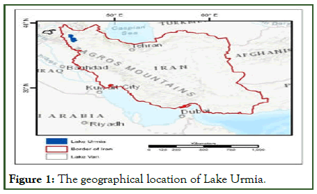
Figure 1: The geographical location of Lake Urmia.
Contributing factors
Generally, all factors affecting the Lake Urmia water surface recession fall under two main categories: Natural factors and human-related factors. Natural factors include cyclic drought and low river flow. Excessive use of groundwater, dam construction and the Kalantari causeway would be classified as human-related factors. What follows explains the factors mentioned earlier and discuss their impact on this environmental phenomenon. Therefore, shrinking Lake Urmia would not be a consequence of only human impact [2]. Climate has been playing an important role in this region although Lake Urmia is close to Lake Van (Figures 2 and 3).
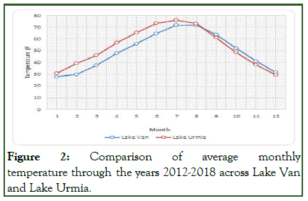
Figure 2: Comparison of average monthly temperature through the years 2012-2018 across Lake Van and Lake Urmia.
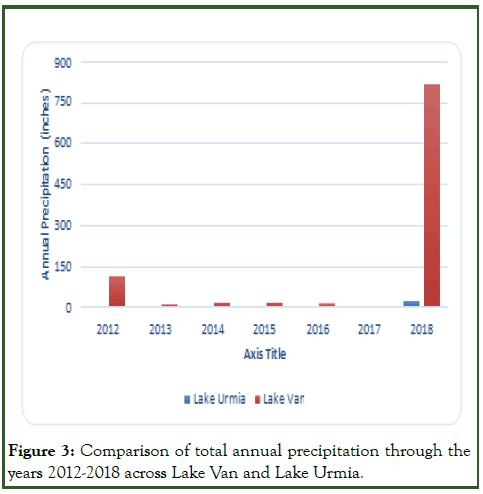
Figure 3: Comparison of total annual precipitation through the years 2012-2018 across Lake Van and Lake Urmia.
Results and Discussion
Another practical reason for the current condition of Lake Urmia would be and the drought cycle and consequently the decreasing trend of the rivers' discharge into the lake (low precipitation, high evaporation and the raised temperature) [3]. However, although changes in the climate condition and rivers' flow have contributed to the current condition of the lake, it cannot be considered as the only consequence of those natural factors since Lake Urmia had experienced even more severe climate conditions and had recovered afterward (Table 1).
| Rivers | Average flow (1967-2002) | Average flow (1990-2004) |
|---|---|---|
| Zarineh Rood | 64.96 | 61.33 |
| Simineh Rood | 16.93 | 3.09 |
| Nazloo Chai | 13.31 | 7.39 |
| Aji Chai | 13.18 | 10.87 |
| Godar Chai | 12.62 | 9.75 |
| Mahabad Chai | 9.18 | 7.97 |
| Barandooz Chai | 8.85 | 7.75 |
| Shahr Chai | 5.38 | 5.26 |
| Zola Chai | 4.57 | 1.74 |
| Sofi Chai | 4.05 | 3.99 |
| Mardoogh Chai | 2.66 | 2.53 |
| Ghaleh Chai | 2 | 1.51 |
| Lailan Chai | 1.78 | 1.74 |
| Daryan Chai | 0.49 | 0.59 |
| Azarshahr Chai | N/A | 1.85 |
| Roze Chai | N/A | 1.22 |
| Kherkhere Chai | N/A | 1.14 |
Table 1: Average discharge of the main rivers into the lake.
Human-related factors
Although natural factors can negatively affect the lake’s condition, environmental scientists believe that the human impacts on the drying of the lake are much more pronounced. Dam construction on the rivers that feed the lake, outdated methods of irrigation and depletion of groundwater and causeway construction are the most important factors which adversely influenced lake ecology. Patterns of land-use seem to be an important factor to affect the function of environment, landscape and hydrology [4]. As an instance, streamflow varies not also based on the precipitation variations but changes also based on water consumption for different purposes such as irrigation, industry, urban, etc.
Shahid Kalantari causeway
Another possible reason for lake shrinkage is the interruption in water flow between the southern and northern parts of the lake caused by the construction of the 15.4-Km dike-type causeway across the lake (Figure 4). The idea of the causeway, which was inspired by the causeway across the great Salt Lake, UT, was proposed in 1979. However, the project remained inactive until the early 2000s. Its first phase was completed in 2008. This highway can improve the tourism industry, reduce the distance between Tabriz and Urmia, lower fuel consumption and decrease fatal accidents. Nevertheless, causeway construction has been environmentally controversial [5].
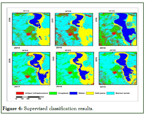
Figure 4: Supervised classification results.
Detrimental impacts of Lake Urmia recession
Avoiding the earth’s surface from the expansion of salt pans is important for agricultural management in arid/semi-arid regions because salt pans can negatively affect human life, wildlife, ecology and cause accelerated desertification, cropland loss and economic downturn. Salt pans and salt playas are shallow expanses of ground surface that are covered or contaminated by salt evaporites. Salt pans are usually formed in terminal lake basins or depressions in arid environments due to excessive evaporation compared to surface inflow and precipitation [6]. All environmentalists, scientists, common citizens and government managers unanimously agree that the drying of the lake has a severely adverse impact on the ecosystem, the economy and people's health and lives. Most people understand as well that to reverse the trend would be almost impossible and very costly. The following lines briefly highlight four of the most important consequences of this serious environmental catastrophe.
Salt storm
When the volume of salt in Lake Urmia expands, the small grains of salt are subject to being scattered through the air by winds. A salt storm can negatively impact the agricultural sector by destroying farmlands and orchards and turning them to the desert, eroding soil, burning plants and crops and endangering livestock. The results of some studies which have modeled salt storms revealed that salt grains can be dispersed as far as 700 Km. This implies that not only will people living around the lake suffer from salt storms and might have to migrate to other areas, but many people in more distant regions, such as neighboring countries and even the capital city Tehran, will be influenced by salt dust [7].
Restoration plans for the lake
Unfortunately, there has not been appropriate attention to Lake Urmia’s deteriorating condition in the past decade and almost no practical actions were taken. Previous Iranian governments had some sensible plans and other fanciful ones to restore Lake Urmia, but all of them were not studied comprehensively and accurately. An example of reasonable solutions was to increase the efficiency of irrigation methods.
Although this type of plan seems to be practical and helpful at first glance, not having enough studies about its possible unintended negative consequences could result in adverse sideeffects. Why? Using advanced and efficient methods of irrigation will enable farmers to cultivate higher-value crops, which in turn have require more water [8]. This increase in water demand, coupled with the possible lack of regulations and limitations of water management promotes higher water use.
The current government approved a 10-year plan called the Lake Urmia Restoration Program (ULRP) prepared by the Iran department of environment in collaboration with the United Nation Development Program (UNDP) in March 2014.
Change detection
To identify differences in the state of land features by observing them at different times Landsat-8 OLI images from 2014 to 2019 are used and different phases of Lake Urmia restoration are monitored in this paper [9]. The maximum likelihood, supervised classification approach, was done on the data from 2014 to 2019 to visualize different zones of land use and their change over time. There is some confusion in differentiating salt pans from urban areas due to similarities in the spectral behavior of these land features. However, in general, it can be inferred that in this period there is not huge urban expansion across the study region so surviving the lake can be more manageable [10]. According to the climate data, the Urmia Lake region experiences a good amount of precipitation in 2018 and the progress in surviving the lake was not unexpected. In 2016 regardless of having low precipitation and high temperature, Lake Urmia restoration showed progress so that large areas of surrounded salt pans are covered under the water [11]. It can be inferred that water resource management has a huge impact on surviving reservoirs and disaster management (Figure 5) [12].
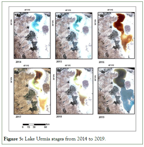
Figure 5: Lake Urmia stages from 2014 to 2019.
Conclusion
First of all, close land features do not necessarily behave similarly due to their different geographical locations and features. Therefore, comparing two close lakes (Lake Van and Lake Urmia) does not provide solid results. Lake Urmia is the largest and most unique ecosystems in the world has experienced a dramatic decrease in area and water level which is attributed to natural and human-related factors including severe climate conditions, reduced river flows into the lake, the construction of a series of dams, the excessive use of surface and underground water for agriculture and the construction of a causeway.
Although the impact of each contributing factor is still debatable among experts and researchers, all agree that the lake’s worrying condition is influenced by all the factors, the primary of which are intensive agricultural activities and the wasteful use of water resources. This is a major concern because the “death” of the Lake Urmia would contribute to many serious environmental, economic and health-related problems. Although some experts believe that it is too late to save Lake Urmia, others hold that immediate local, national and even international actions must be taken to prevent the lake from completely vanishing. Lake Urmia requires three billion cubic meters of water per year in ten years to recover its original condition. Landsat images point to the progress in water resource management and survival of the lake although the country has been experiencing sanctions for a long time and needs to provide foods locally, compared to the other countries.
References
- AghaKouchak A, Norouzi H, Madani K, Mirchi A, Azarderakhsh M, Nazemi A, et al. Aral Sea syndrome desiccates Lake Urmia: Call for action. J Great Lakes Res. 2015;41(1):307-311.
- Ahmadzadeh Kokya T, Pejman AH, Mahin Abdollahzadeh E, Ahmadzadeh Kokya B, Nazariha M. Evaluation of salt effects on some thermodynamic properties of Urmia Lake water. Int J Environl Res. 2011;5(2):343-348.
- Asem A, Mohebbi F, Ahmadi R. Drought in Urmia Lake, the largest natural habitat of brine shrimp Artemia. World Aquac. 2012;43(1):36-38.
- Gaybullaev B, Chen SC, Kuo YM. Large-scale desiccation of the Aral Sea due to over-exploitation after 1960. J Mt Sci. 2012;9:538-546.
- Ghalibaf MB, Moussavi Z. Development and environment in Urmia Lake of Iran. Eur J Sustain Dev. 2014;3(3):219-226.
- Karbassi A, Bidhendi GN, Pejman A, Bidhendi ME. Environmental impacts of desalination on the ecology of Lake Urmia. J Great Lakes Res. 2010;36(3):419-424.
- Abbaspour M, Javid AH, Mirbagheri SA, Ahmadi Givi F, Moghimi P. Investigation of lake drying attributed to climate change. Int J Environ Sci Technol. 2012;9:257-266.
- Micklin P. The Aral Sea disaster. Annu Rev Earth Plane Sci. 2007;35(1):47-72.
- Micklin PP. Desiccation of the Aral Sea: A water management disaster in the soviet union. Science. 1988;241(4870):1170-1176.
[Crossref] [Google Scholar] [PubMed]
- Mirchi A, Madani K, Watkins D, Ahmad S. Synthesis of system dynamics tools for holistic conceptualization of water resources problems. Water Resour Manag. 2012;26:2421-2442.
- Small I, van der Meer J, Upshur RE. Acting on an environmental health disaster: The case of the Aral Sea. Environ Health Perspect. 2001;109(6):547-549.
[Crossref] [Google Scholar] [PubMed]
- Tourian MJ, Elmi O, Chen Q, Devaraju B, Roohi S, Sneeuw N. A spaceborne multisensor approach to monitor the desiccation of Lake Urmia in Iran. Remote Sens Environ. 2015;156:349-360.
Citation: Safaee S (2024) Restoring Environmental Catastrophe in Iran; Lake Urmia. J Remote Sens GIS. 13:350.
Copyright: © 2024 Safaee S. This is an open-access article distributed under the terms of the Creative Commons Attribution License, which permits unrestricted use, distribution and reproduction in any medium, provided the original author and source are credited.

