Indexed In
- Open J Gate
- Genamics JournalSeek
- JournalTOCs
- China National Knowledge Infrastructure (CNKI)
- Electronic Journals Library
- RefSeek
- Hamdard University
- EBSCO A-Z
- OCLC- WorldCat
- SWB online catalog
- Virtual Library of Biology (vifabio)
- Publons
- MIAR
- Euro Pub
- Google Scholar
Useful Links
Share This Page
Journal Flyer

Open Access Journals
- Agri and Aquaculture
- Biochemistry
- Bioinformatics & Systems Biology
- Business & Management
- Chemistry
- Clinical Sciences
- Engineering
- Food & Nutrition
- General Science
- Genetics & Molecular Biology
- Immunology & Microbiology
- Medical Sciences
- Neuroscience & Psychology
- Nursing & Health Care
- Pharmaceutical Sciences
Research Article - (2021) Volume 12, Issue 9
Fine Scale Geological Modeling Techniques in Kela 2 Gas Field
Zhaolong Liu1*, Yongzhong Zhang1, Hualin Liu1, Dong Chen2, Min Yang2, Ming Li2, Peng Zhou2, Zhenhua Guo1 and Weigang Huang12PetroChina Tarim Oilfield Company, Northwest Xinjiang, China
Received: 03-Sep-2021 Published: 24-Sep-2021, DOI: 10.35248/2157-7463.21.12.436
Abstract
As the major gas resource of the West-East Gas Transmission Project, Kela 2 gas field plays an important role in the natural gas industry development and social demand in China. After 17 years development, annual gas production of Kela 2 gas field is stable in over 5 billion cubic meters, which has great reference value for the other gas field’s development. Kela 2 gas field is in the middle-late development period at present, some gas wells experienced water flooding in advance, which has resulted in a productivity decrease. Main challenges at current development period are development scheme adjustments such as water invasion prevention, water invasion control, production allocation optimization, and the conventional geological modeling cannot meet the scale requirement for the development scheme adjustment. By using the fine scale geological modeling techniques, it could provide a basis for the study of remaining reserves distribution, horizontal well deployment, water control and drainage scheme design.
Keywords
Tarim Basin; Kela 2 gas field; Structural modeling; Facies modeling; Petrophysical modeling; Discrete fracture network modeling
Introduction
In 1998, the completion testing of Well Kela 2 showed high-yield gas layers, which marked the successful discovery of Kela 2 gas field [1-3]. Kela 2 gas field is located in the Kelasu structural belt of the Kuqa depression, Tarim Basin, and the sedimentary facies are mainly alluvial fans, fan deltas, and braided river deltas (Figure 1) [4]. The major reservoirs are the Paleogene dolomite formation, Kumgeliemu group dolomite formation, glutenite formation and cretaceous Bashijiqike thick sandstone Formation, and the total formation thickness is 400-530 m. Kela 2 gas field is a mediumporosity and medium-permeability reservoir, with an average logging porosity of 13.8% and an average logging permeability of 37 × 10-3 μm2 [5-7]. Kela 2 gas field is a normal temperature, abnormally high-pressure block edge-bottom water dry gas reservoir, with the original formation pressure of 74.35 Mpa, the formation pressure coefficient of 2.02, and the original formation temperature of 100°C [8].
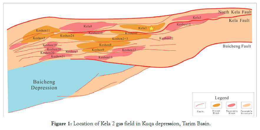
Figure 1: Location of Kela 2 gas field in Kuqa depression, Tarim Basin.
Up to June 2021, there are 23 production wells in Kela 2 gas field, which has 19 wells in production currently. Cumulative gas production is 124.5 billion cubic meters with a gas recovery ratio of 43.8%. Formation pressure of single wells decreased simultaneously, which indicates good reservoir connectivity. There are 11 wells producing water, mainly located in the southwestern and eastern area (Figure 2). Inhomogeneous water invasion causes the production decreasing, which will affect ultimate recovery of Kela 2 gas field in the future. In order to indicate and control the water invasion, it is necessary to build a fine scale geological modeling to support the development scheme adjustments.
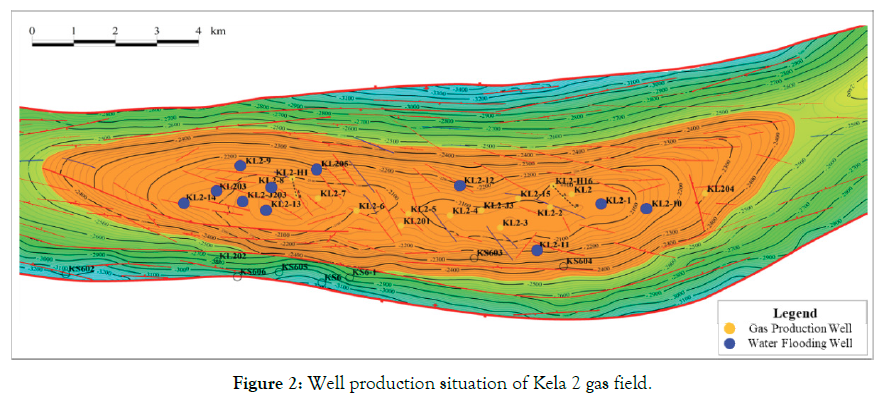
Figure 2: Well production situation of Kela 2 gas field.
Methods
Fine scale geological modeling techniques
Combining with static and dynamic data, fine scale geological modeling techniques quantitatively characterize geological structures, sedimentary facies, reservoir characteristics, fluids characteristics and other related parameters [9-12]. According to the development and numerical simulation demand, fine scale structural model, facies model, matrix petrophysical model and fracture model were built in this paper. Figure 3 shows the flow chart of modeling technique based on Petrel.
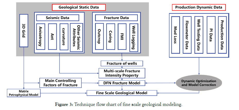
Figure 3: Technique flow chart of fine scale geological modeling.
Fine scale structural modeling
Based on the fine scale 3D seismic interpretation, geological surfaces and faults are imported into Petrel to model the geological structure. There are 158 faults in Kela 2 gas field, and 114 faults are in the gas trap. According to the fault occurrence, 158 faults are divided into 7 groups to build the 3D fault models (Figure 4). Through analysis of the fault models, it is found that the fault length of Kela 2 gas field is mainly distributed in the range of 200-3000 m, and small-throw and high-angle faults are mainly developed in the gas trap. There are 51 faults run through the whole formations.
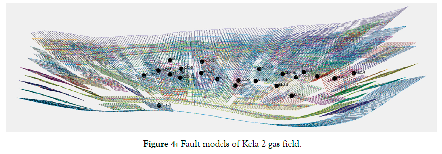
Figure 4: Fault models of Kela 2 gas field.
From seismic interpretation data, there are 13 structural surfaces from Dolomite formation to Shushanhe Formation River. All the structural surfaces have the good quality and used to build the surface models with well tops (Figure 5). In order to meet the scale demand of fine modeling and numerical simulation, the plane grid is set as 100 m × 100 m, while the vertical grid is set as 535 layers. The grid number of structural model is 231 × 55 × 535=6797175 in total.
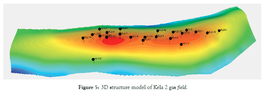
Figure 5: 3D structure model of Kela 2 gas field.
Facies modeling
Stochastic object is used to build the facies models in the paper. Based on the stratigraphic correlation, 5 facies of dolomite, gypsum mudstone, glutenite, sandstone and mudstone are simulated separately. Through the outcrops survey in Kelasu River Mountain, interlayers characteristics of Kelasu reservoir were described and made statistical analysis. Interlayers thickness of 2-4 m could be extend to about 450 m, and they have a good extension in the plane. These interlayers could form in a small area, which could play as barriers to prevent the liquid migration. Interlayers thickness of 1-2 m could be extend to less than 200 m. Interlayers thickness of smaller than 1 m could only extend 10-30 m, the plane extension is short and they have no barrier effect on the fluid migration.
Through analysis of the well logging, the interlayer thickness is 0.3- 1.6 m in Kela 2 gas field, the interlayer density is 0.19 meter per meter, and the interlayer frequency is 0.17 number per meter. From the statistical outcrop data, interlayers of Kela 2 gas field are only developed in partial area and they have no barrier effect on the fluid migration (Table 1). In the facies modeling process, development scale of mudstone interlayers (length, width, thickness, azimuth, dip) are set based on the statistical outcrop data and interlayer distribution analysis. Facies model shows the sedimentary characteristics of braided river deltas, which is consistent with early geological understandings (Figure 6).
| Well | Effective Thickness (m) | Interlayer Number | Interlayer Thickness (m) | Interlayer Density (m/m) | Interlayer Frequency (Number/m) | Average Thickness (m) |
|---|---|---|---|---|---|---|
| KL2-14 | 248.1 | 56 | 76.2 | 0.31 | 0.23 | 1.36 |
| KL203 | 316.5 | 35 | 62.8 | 0.20 | 0.11 | 1.79 |
| KL2-9 | 286.1 | 46 | 63.4 | 0.22 | 0.16 | 1.38 |
| KL2-J203 | 363 | 30 | 57.9 | 0.16 | 0.08 | 1.93 |
| KL2-13 | 393.5 | 81 | 113.2 | 0.29 | 0.21 | 1.40 |
| KL2-8 | 368 | 51 | 101 | 0.27 | 0.14 | 1.98 |
| KL2-7 | 339.9 | 61 | 95.2 | 0.28 | 0.18 | 1.56 |
| KL205 | 240 | 28 | 29.9 | 0.12 | 0.12 | 1.07 |
| KL2-6 | 299.8 | 60 | 82.8 | 0.28 | 0.20 | 1.38 |
| KL201 | 302.2 | 34 | 51.2 | 0.17 | 0.11 | 1.51 |
| KL2-5 | 262.7 | 25 | 28 | 0.11 | 0.10 | 1.12 |
| KL2-4 | 360.4 | 34 | 52.7 | 0.15 | 0.09 | 1.55 |
| KL2-12 | 244.2 | 58 | 87.7 | 0.36 | 0.24 | 1.51 |
| KL2-3 | 380.1 | 28 | 49.6 | 0.13 | 0.07 | 1.77 |
| KL2-15 | 306.5 | 59 | 86.5 | 0.28 | 0.19 | 1.47 |
| KL2-11 | 255.2 | 45 | 65.2 | 0.26 | 0.18 | 1.45 |
| KL2-2 | 350.7 | 37 | 61 | 0.17 | 0.11 | 1.65 |
| KL2 | 351.7 | 50 | 75.2 | 0.21 | 0.14 | 1.50 |
| KL2-1 | 368.9 | 33 | 43 | 0.12 | 0.09 | 1.30 |
| KL2-10 | 287.1 | 31 | 39.5 | 0.14 | 0.11 | 1.27 |
| KL204 | 143.4 | 12 | 10 | 0.07 | 0.08 | 0.83 |
Table 1: Statistical interlayer’s data of Kela 2 gas field.
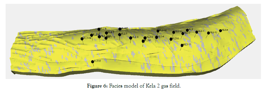
Figure 6: Facies model of Kela 2 gas field.
Matrix petrophysical modeling
Petrophysical modeling includes porosity modeling, permeability modeling and saturation modeling. Modeling method selects the sequential Gaussian simulation with facies controlled. In the porosity modeling, petrophysical distribution range and trend of input data are analysis by separate layers and facies, and then using variogram analysis to determine the range value in major direction and minor direction separately. Due to a good correlation between porosity and acoustic impedance from seismic interpretation, acoustic impedance of separate layers are used as trend constraints during porosity modeling process (Figure 7). In the permeability modeling, porosity model is used as a second variable trend to constraint the simulation (Figure 8). Porosity and permeability models are consistent with early geological understandings.
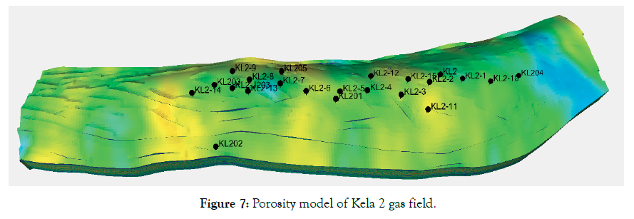
Figure 7: Porosity model of Kela 2 gas field.
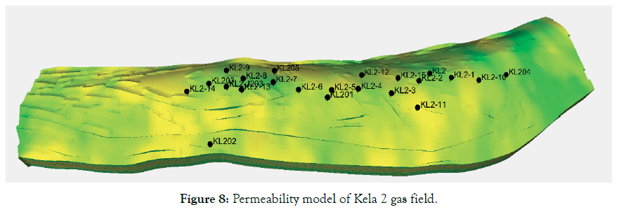
Figure 8: Permeability model of Kela 2 gas field.
Fracture modeling
Using multi-conditions and multi-scales constraints, Discrete Fracture Network (DFN) simulation is used to build the fracture model in this paper [13,14]. Kela 2 gas field mainly develops high angle structural fractures, which are controlled by faults and geostress. Kela 2 gas field is an anticline formed by the compressive stress in north-south direction, which fractures developed most in the structural axis and near faults area. In fracture modeling process, distance from the faults, maximum principal curvature, and the distance from the anticline axis are used as multiple constraints to build the fracture model. Input data are from different scales of outcrop description, seismic data, coring description, FMI interpretation, which are analyzed comprehensively to determine the fracture parameters (Figure 9).
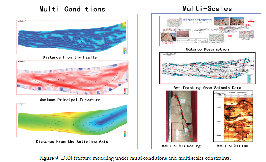
Figure 9: DFN fracture modeling under multi-conditions and multi-scales constraints.
Fracture parameters mainly contain distribution, geometry, orientation and aperture. From the analysis above, parameters are inputted into DFN module to build the fracture model (Figure 10). Fracture spatial distribution is based on the distance from the faults, maximum principal curvature, and the distance from the anticline axis. Finally, upscale the DFN model and obtain the equivalent fracture porosity and permeability.
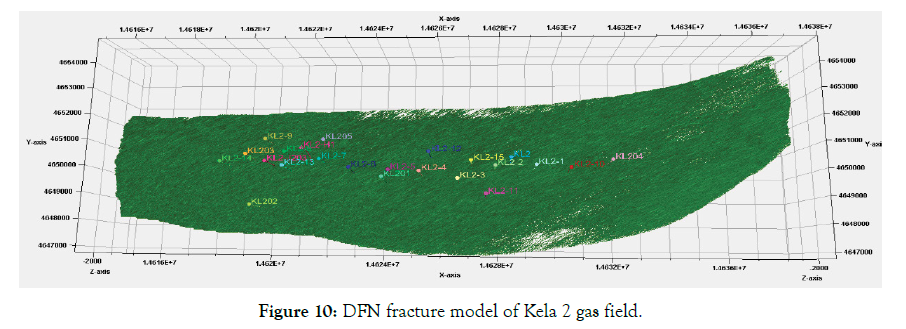
Figure 10: DFN fracture model of Kela 2 gas field.
Results and Discussion
After upscaling the geological model of Kela 2 gas field, the model is imported into Eclipse to make the numerical simulation. Fixed production system is used in Kela 2 gas field, and we build the simulation model to predict the future production situation by history matching of flowing pressure and water production. Since development from 2004, Kela 2 gas field has obtained plenty of dynamic production data. From numerical simulation on 22 production wells, first-time fitting rate of single well gas production reaches 100%, first matching ratio of gas production is 100% and the first matching ratio of flowing pressure is 70% (Figure 11). While, first matching ratio of water production is also over 50% for the 9 water flooding wells. The entire matching ratio is more than 50%, which indicates the good reliability of this fine scale geological model.
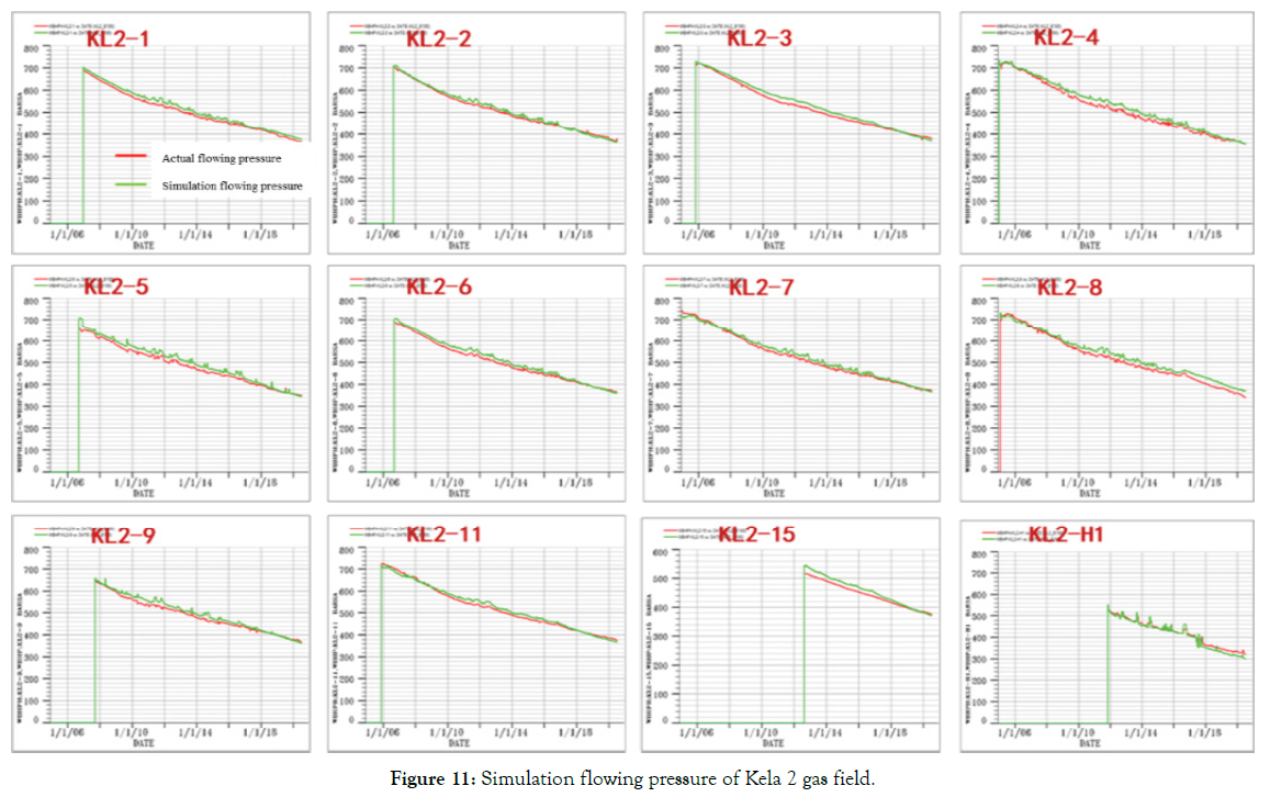
Figure 11: Simulation flowing pressure of Kela 2 gas field.
Conclusion
Using fine scale geological modelling techniques, geological models could meet the scale demand of middle-late development period for the Kela 2 gas field, and it could provide a basis for the study of remaining reserves distribution, horizontal well deployment, water control and drainage scheme design.
Fine scale geological modelling techniques include structural modelling, facies modelling, matrix petrophysical modelling and fracture modelling. Combining with static and dynamic data, multi-conditions and multi-scales data are constrained to improve the accuracy of the geological models, which are more coincidence with the of geological understandings.
Fine scale geological modelling techniques show good application effects in Kela 2 gas field. The entire initial production matching ratio is more than 50% after the numerical simulation, which indicates that geological model has a good reliability by using fine scale geological modelling techniques.
REFERENCES
- Jia C, Zhou X, Wang Z, Pi X, Li Q. Discovery of Kela-2 gas field and exploration technology. China Petrol Explor. 2002;7:79-88.
- Li B, Zhu Z, Xia J, Ma C. Development Patterns and key techniques of coal-formed Kela 2 gas field. Pet Explor Dev. 2009;36:392-397.
- Wang T, Zhu Z, Li N, Chen Z, Wu Z. Technical guideline at the initial stage of exploitation of as large-scale mono-block abnormal over-pressure gas field: Taking Kela 2 gas field as an example. Nat Gas Geosci. 2006;17:439-444.
- Jiang T, Zhang H, Wang H, Yin G, Xiao X. Effects of faults geo-mechanical activity on water invasion in Kela 2 gas field, Tarim Basin. Nat Gas Geosci. 2017;28:1735-1744.
- Chu G, Shi S, Shao L, Wang H, Guo Z. Contrastive study on geological characteristics of cretaceous Bashijiqike formation in Keshen2 and Kela2 gas fields in Kuqa depression. Geosci. 2014;28:604-610.
- Han D, Li Z, Shou J. Reservoir Property Difference between Structural Positions in the Anticline: A case study from Kela-2 gas field in the Kuqa depression, Tarim Basin, Northwest China. Petrol Explor Devel. 2011;38:282-286.
- He D, Ying F, Zheng J, Guo H, Zhu R. Numerical simulation of clastic diagenesis and its application. Petrol Explor Devel. 2004;31:66-68.
- Wu Y, Yang M, Li M, Sun Y, Zhang Y, Wang H. Laws and Models of Water Invasion in Kela 2 gas field. Xinjiang Petrol Geo. 2019;41:302-306.
- Liang W, Dang H, Cui P, Wang X, Hou P, Zhang T. Application of 3D geological modeling in horizontal well development of tight sandstone oil reservoirs: A case study of Block-S in Ordos Basin. Xinjiang Petrol Geo. 2020;41:616.
- Jia A, Tang J, He D, Ji Y, Cheng L. Geological modeling for sandstone reservoirs with low permeability and strong heterogeneity in Sulige gas field. China Petrol Explor. 2007;12:12-16.
- Jia A, He D, He W, Zhang C, Guo J. Application of outcrop geological knowledge database to prediction of inter-well reservoir in oilfield. Acta Petrolei Sinica. 2003;24:51-58.
- Ren D, Li F, Li B. Geo-modeling technology under multifactor control. Petrol Explor Devel. 2008;35: 205-214.
- Wang J. DFN Model: A new modelling technology for fracture. J Fault-Block Oil & Gas Field. 2008; 15:55-58.
- Lang X, Guo S. Fractured reservoir modeling method based on discrete fracture network model. Acta Sci Nat Univ Pekinensis. 2013;49:964-972.
Citation: Liu Z, Zhang Y, Liu H, Chen D, Yang M, Li M, et al. (2021) Fine Scale Geological Modeling Techniques in Kela 2 Gas Field. J Pet Environ Biotechnol. 12:436.
Copyright: © 2021 Liu Z, et al. This is an open-access article distributed under the terms of the Creative Commons Attribution License, which permits unrestricted use, distribution, and reproduction in any medium, provided the original author and source are credited.
