Indexed In
- SafetyLit
- RefSeek
- Hamdard University
- EBSCO A-Z
- OCLC- WorldCat
- Publons
Useful Links
Share This Page
Journal Flyer

Open Access Journals
- Agri and Aquaculture
- Biochemistry
- Bioinformatics & Systems Biology
- Business & Management
- Chemistry
- Clinical Sciences
- Engineering
- Food & Nutrition
- General Science
- Genetics & Molecular Biology
- Immunology & Microbiology
- Medical Sciences
- Neuroscience & Psychology
- Nursing & Health Care
- Pharmaceutical Sciences
Review Article - (2019) Volume 22, Issue 1
Bangladesh Coastal Zone Management Status and Future Trends
Hafez Ahmad*Received: 04-Jan-2019 Published: 30-Jan-2019
Abstract
Coastal Zone (CZ) is the region where land, ocean and atmosphere interact with each other hence it is dynamic and diverse in nature. This zone is being continually attacked by cyclones, sea level rise, storm surge which have caused terrible impacts on this low lying coastal area. The complex and active coastal zone needs to manage and requires an integrated holistic approach. This study aims to identify the background of coastal zone management, scope, the rationality of coastal development, challenges, framework, environmental impacts, and future trends. Currently integrated coastal zone management is mainly used for coastal development strategy in Bangladesh (BD). CZ of BD requires an integrated management to establish a mutual interaction among coastal community, policy, environment to achieve sustainable development of CZ. CZ has development opportunities that can reduce coastal poverty and contribute to the local and overall economic development of Bangladesh. The zone has diversity of natural resources, minerals and tourism potential and much more to explore. Bangladesh already has taken ocean governance initiative.
Keywords
Coastal zone; Coastal zone management; Development strategy; Future trend; InitiativeIntroduction
Coastal zone of Bangladesh is geomorphologically and hydrologically dominated by the Ganges Brahmaputra Meghna (GBM) river system and Bay of Bengal. The coastal zone of Bangladesh covers an area of 47,201 km2, 32% of the country, being the landmass of 19 districts (Figure 1). Around 35 million people, representing 29% of the population, live in the coastal zone. Coastal zone of Bangladesh consists of 19 coastal districts that are Jessore, Narail, Gopalganj, Shariatpur, Chandpur, Satkhira, Khulna, Bagerhat, Pirozpur, Jhalakati, Barguna, Barisal, Patuakhali, Bhola, Lakshmipur, Noakhali, Feni, Chittagong, and Cox's Bazar [1]. Depending on geographic features, coastal zone of Bangladesh consists of three parts, (a) The eastern zone, (b) The central zone, (c) Western zone. The western region known as Ganges tidal plain, comprises the semi-active delta and is crisscrossed by numerous channels and creeks. The central region is the most active and continuous processes of accretion and erosion. Meghna river estuary lies here in this zone. The eastern region is covered by hilly area that is more stable [2]. The coastline is 710 km long which is composed of the interface of various ecological and economic systems, including mangroves (world largest mangrove forest covers 6,017 km2), tidal flat. Estuaries, sea grass, about 70 islands, accreted land, beaches, a peninsula, rural settlements, urban and industrial areas, and ports [3,4]. Many of the coastal inhabitants are poor, and the population is exposed to both natural disasters and man-made hazards. Climate change driven events like sea level rise, cyclone, storm surge, coastal inundation, salinity intrusion and land erosion are main the natural disasters (Figure 1) [4,5].
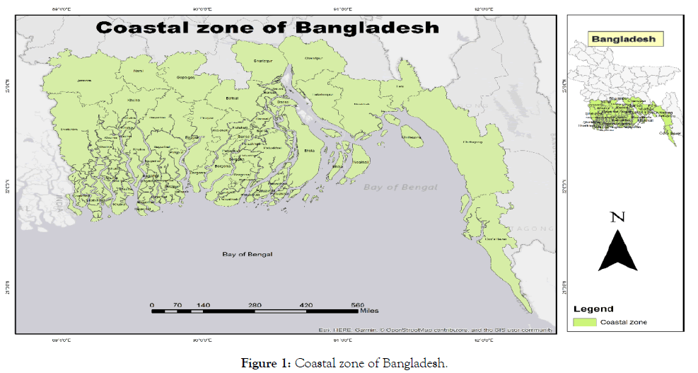
Figure 1: Coastal zone of Bangladesh.
CZ of BD is suffering from a wide range of climate change driven hazards and anthropogenic problems. So this vast coastal area needs management and holistic framework for sustainable development, conservation of coastal ecosystems and safety of coastal communities. The coastal management and development programs of the country took place in the early 1960s through undertaking a number of initiatives such as construction of coastal embankments, building coastal greenbelt, and land reclamation, community based management and delta development [4].
Materials and Methods
This study was based of secondary information and data. To collect secondary data, an intensive literature review related to coastal demographic statistics, coastal development status, coastal management approaches, coastal resources, coastal zone related anthropogenic impacts, coastal government surveys, agriculture statistics issues in Bangladesh context were conducted through an online and offline. In addition, relevant, gazettes, policy documents and government reports were also collected from government agencies through personal contacts. The secondary data and graphic illustrations also was collected from original researchers with permission and open sources software python, R and ArcGIS, MS Excel are used for data analysis and visualization. For data analyses, the “content analysis” method was used. This method is a research tool for interpreting and coding textual material (e.g. documents, books, oral communication, interviews, and graphics) to elicit meaningful information over different themes.
Coastal Habitat and Biodiversity of Bangladesh
Coastal areas are mostly rich bio-diversified. Western part is covered by world largest mangrove forest. The Sundarbans support a very rich and diverse fish fauna of 120 species and over 270 species of birds which provides livelihoods to about 300,000 people at certain seasons of the year working in different trades. Some of coastal areas are carpeted by seagrass with different species. A total of 165 species of seaweed belonging to 77 genera have been reported (Figure 2) [3,6-8].

Figure 2: Coastal major hazards in Bangladesh coast.
Coastal Hazards in Bangladesh Coast
Climate change brings a significant coastal hazards. Bangladesh is one of the country’s most likely to suffer adverse impacts from anthropogenic climate change. Although Bangladesh emits less than 0.1% of global greenhouse gas emissions [9]. It is one of major coastal risks in Bangladesh because it is associated with other natural hazards in a complex way. A 1 m rise in sea level would submerge a full 18% of the total land area in Bangladesh [10]. A research showed that deeply flooded area (depth above 100 cm, duration more than 9 months) would increase by 29% (from the base year 2000) due to 88 cm SLR [11]. The total amount of salinity affected land in Bangladesh was 83.3 million hectares in 1973, which had been increased up to 102 million hectares in 2000 and the amount has raised to 105.6 million hectares in 2009 and continuing to increase [12]. With 50% of the land less than 8 m above sea level, and a coastline of some 600 km, coastal flooding is a common problem [13]. Bangladesh is especially vulnerable to tropical cyclones with around 718,000 deaths from them in the past 50 years [14]. The western coastal zone is particularly vulnerable to surge flooding due to its low-lying land and very poor defiance against surge waves [15]. A GIS based study showed that a total of 1183 km2 of land has eroded with rate 118.3 km2/year from 1995 -2005 and 1194 km2 from 2005 to 2015 around central part of Bangladesh coastal zone. Major erosions occurred in the areas of Meghna estuary and along the coasts of major islands such as the eastern coast of Bhola, the northern coast of Hatiya and the south-western coast of Sandwip [16]. The future vulnerability in the coastal region of Bangladesh will be significantly higher than present condition [17].
Natural disasters such as cyclone, storm surge, floods, and drought will be more frequent and intense in the future. The climate vulnerability will be enhanced in the coastal region of Bangladesh due to geographic settings, dense population, and poverty. central and western part of coastal areas are more vulnerable (Figure 3) because western part mostly covered Sundarbans but it is low lying land areas, other central part is more dynamic part of the coastal zone of Bangladesh.
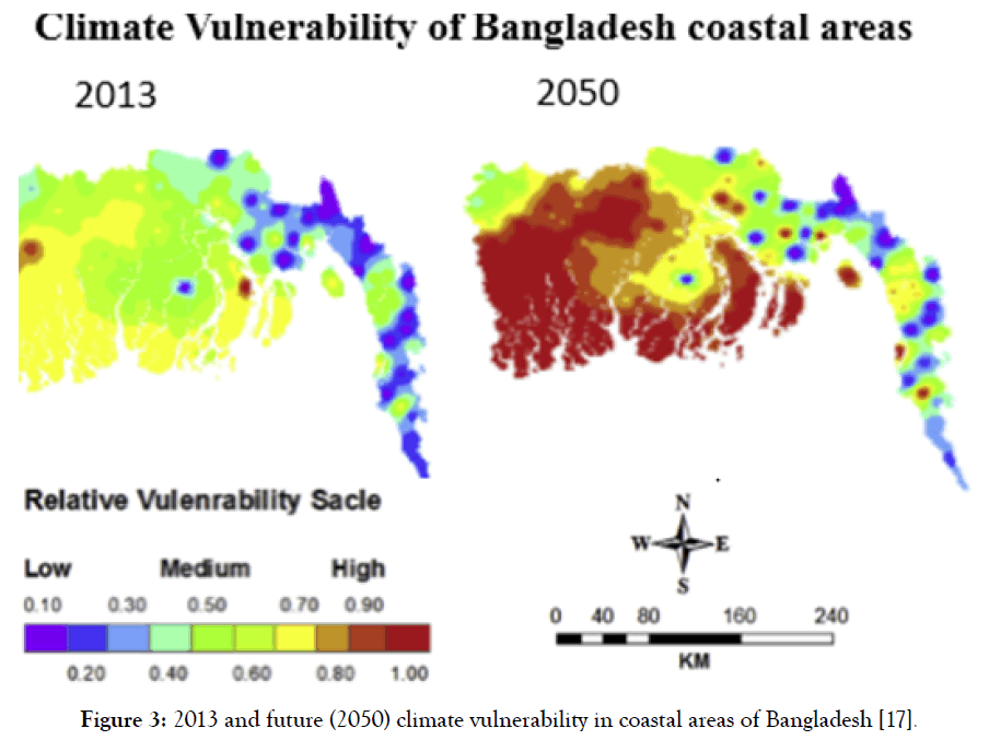
Figure 3: 2013 and future (2050) climate vulnerability in coastal areas of Bangladesh [17].
Integrated Coastal Zone Management ICZM) Approach
ICZM is a widely accepted approach at all levels of governance as a means of delivering sustainable development in the coastal areas [18]. ICZM refers to ‘ a dynamic, continuous and iterative process designed to promote sustainable management of coastal zones which covers full cycle of information collection, planning, decision making, management and monitoring of implementation’ [19]. Coastal zone management is to provide for the best long-term sustainable use of coastal natural resources and for perpetual maintenance of the most beneficial natural environment. It unites government, community, management, sectorial interests for the protection and development of coastal ecosystems and resources. People’s participation is always requirement in any development program. ICZM ensures it in effective way (Table 1).
Table 1: There are several basic common stages in the generation of an ICZM [20].
| 1: Policy formulation | 2: Strategy planning | 3: Program development | 4: Implementation |
|---|---|---|---|
| Creating of a policy framework to establish goals and to authorize and guide the ICZM program. | Potentials impacts of ICZM policy action are explored where benefits are evaluated and where data is accumulated and where general strategy is created and recommendations are made for organization. | Once the strategy plan is accepted by policy makers, development of the ICZM program can commence and details master plan for its implementation be created. | Once the master plan is approved and a budget and staff are authorized. The implementation stage can commence |
ICZM addresses national concerns for coastal waters and natural habitats (mangrove, coral reef, and sea grass) and adjacent coastal areas. It provides a method to resolve problems of interaction between coastal lands and coastal waters. To establish the success of ICZM also requires institutional support and legislative instruments to ensure the participation all relevant people. Bangladesh Government (BDG) took several initiatives to protect and pay safety and sustainable development for coastal communities (Table 2).
Table 2: Previous Bangladesh coastal management strategies [21].
| 1 | Off shore islands development boards (1977-1982) |
|---|---|
| 2 | Bangladesh national conversation strategy (1987) |
| 3 | Coastal environment management plan for Bangladesh (1987) |
| 4 | Coastal areas resources development plan (1988) |
| 5 | Special parliamentary committee on coastal area development (1998-1990) |
| 6 | National capacity building approach the ICZM initiative (1997) |
| 7 | Coastal zone policy (2005) |
| 8 | Tsunami vulnerability map (2005) |
| 9 | Coastal development strategy (2006) |
All initiatives based on ICZM. BDG implemented a number of measures to support planning and management in coastal areas.
Present Status and Future Trend of Coastal Zone Management
Recently coastal zone management, development and planning have received serious attention by BGD. The ICZM approach not only helps mitigate the effects of disasters, but also provides opportunities for sustainable resource utilization. ICZM in Bangladesh is not just for environmental or ecological gain but provides a survival strategy for millions living at the mercy of nature [22]. The adoption of the 2005 Coastal Zone Policy and strategy in Bangladesh was a significant step towards implementing ICZM. The Coastal Zone Policy (CZP) of 2005 was adopted with the overall goal to create conditions in which the reduction of poverty, development of sustainable livelihoods and the integration of the coastal zone into national processes can take place [23]. CZP aimed to provide a general guidance to all concerned for management and development of the CZ in a manner so that coastal people are able to pursue their life and livelihood (Table 3).
Table 3: Scopes, works, challenges, opportunities and threats of ICZM in Bangladesh.
| Scopes of ICZM in Bangladesh | Issues of ICZM in Bangladesh |
|---|---|
| 1: management of coastal community 2: management of coastal resources 3 : management of environment 4: management of coastal economy |
1: population growth and poor infrastructure 2: supply and demand analysis 3: analysis of opportunities 4 :assessment of coastal risks and challenges |
| Challenges | Opportunities |
| 1: weakness in policy 2: lack of coordination 3: inadequate human resources 4: lack of investment 5: inadequate public participation and stakeholder inclusion. |
1: long and large coastal area 2 : enriched with resources coastal zone 3: biodiversity of coastal ecosystems 4: largest mangrove forests |
| Major threats to coastal areas | |
| 1: over population 2: over exploitation of coastal resources (coastal fisheries are mostly over exploited by destructive and illegal gears ) 3: coastal pollution (municipal wastes from major coastal cities) 4: rapid environmental changes (climate changing and ocean acidification) 5: constrains of law and policy |
|
The Coastal Zone Management Policy (CZMP) in Bangladesh includes a wide range of issues from economic development to ecosystem protection and conservation. But there has no particular option to address natural disaster or reduction of vulnerabilities. There is no clear guideline on how local development agencies should work with government bodies. This is the limitation of CZMP. So initiative has seemingly died off after 2005-2006, and has failed to show any great promise There were some reasons such as (i) Failure to incorporate professionals qualified in Coastal Zone Management, (ii) unreasonably land-centric view of the coastal zone, (iii) failure to assemble a regular workforce etc.
Initiatives of Bangladesh for Coast and Marine Management
Some development initiatives have recently been taken and some are in the process of being initiated in different sectors, namely shipping, fisheries, environment, research, etc. to either boost economic growth or to manage the capital resources more sustainably. Recently Bangladesh oceanographic research institute founded for coastal and oceanic research of all kinds. Several Ecologically Critical Areas (ECA) have been enforced in various coastal ecosystems to maintain critical habitats, biodiversity, marine turtle breeding and conservation, and mangrove restoration and growth. Mangrove afforestation in newly accreted intertidal areas has been going on for decades now [24,25].
Ocean Governance Framework
An integrated coastal and ocean governance framework for Bangladesh has been proposed in the 7th Five Year Plan (2016- 2020) of the country by the Planning Commission of Bangladesh. This is made for coastal and ocean affairs for Bangladesh. This is the first holistic coastal and ocean management policy framework that includes the ocean as part of integrated coastal and ocean management. This structure can be further extended to include cross border and, regional collaborations especially in the environment, river and island management, conservation and scientific research (Figure 4) [26].
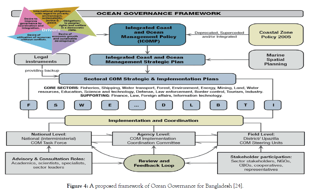
Figure 4: A proposed framework of Ocean Governance for Bangladesh [24].
After completing all related tasks, health of coastal community, coastal biodiversity, coastal protection and coastal livelihood have been improved (Figure 5).
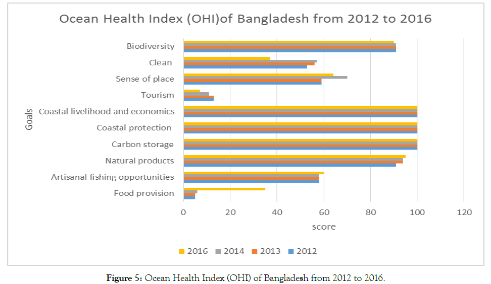
Figure 5: Ocean Health Index (OHI) of Bangladesh from 2012 to 2016.
The average OHI score in Bangladesh in 2014 was far better than the previous years, with a one point increase in each year since 2012 (from 67 in 2012 to 69 in 2014, 69 in 2016). Bangladesh is ranked 100 out of 221 EEZs with overall score 69 [27].
Delta Plan 2100
The government of Bangladesh in cooperation with Netherlands jointly have explored the possibility of drawing up a delta plan for Bangladesh which is integrated and holistic plan, to ensure safe living and sound economic development in Bangladesh. This will provide a complete strategy for development of delta project for next 50 to 100 years. It will be a road map towards of coordinated and prioritized investment in land and water management, continuously bringing in latest knowledge, leading to the desired future in 2100 (Figure 6).
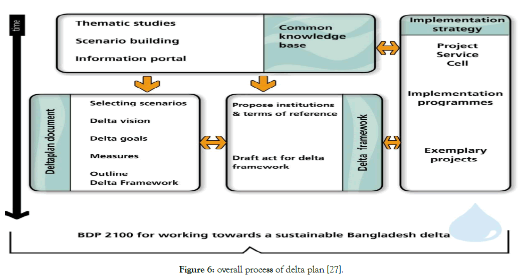
Figure 6: Overall process of delta plan [27].
Delta Plan 2100 has the following Specific Objectives
Support an enabling sociopolitical climate so BDP 2100 can be formulated and implemented,
Create a common, inclusive, and documented knowledge base for water, land, and related natural resources, as well as spatial planning in the Bangladesh delta with emphasis on water, land, agriculture, public health, environment, disaster management, food security, economic growth, and spatial and ecological development, and using this knowledge base to undertake integrated analyses and scenario building with the main stakeholders [28].
Develop a Delta Framework and prepare a draft Act to establish a Delta Framework encompassing necessary and agreed upon reforms of the current institutional framework as well as the involved governmental organizations so they are prepared to formulate BDP 2100 and implement the plan in an integrated, targeted, inclusive, broadly supported, and transparent manner.
Create with the main stakeholders a delta vision, goals, and measures that use a policy-making process that is adaptive, inclusive, and transparent, ensure the transparent input of both the public and private sector, and provide the anticipated results in the BDP 2100.
Facilitate entrepreneurship of the private sector, including multinational companies, small-scale and medium enterprises, and NGOs, in Bangladesh and in The Netherlands for ideas, concepts, and innovations that contribute to the BDP 2100 through links to public institutions and other relevant organizations in Bangladesh and that promote short-term regional and sectorial developments leading to appropriate future governance of water, land, and related resources as well as spatial planning in Bangladesh delta.
Conclusion
Coastal zone management is very challenging because it must address related all issues in socioeconomic and natural but is very important in Bangladesh coastal zone that holds one thirds population of Bangladesh are now standing in a multiple challenges. The output of ICZM is not satisfied. Coastal management approaches depend on the information available on various aspects of coastal ecosystems, processes, resources, natural hazards and their impacts, effective response by government. Coastal zone management is the essential for implementing sustainable development strategy in Bangladesh. The most important is to have interlinked among the national level, sub-national level and local community in any approaches that could ensure safety, security and sustainability for the coastal communities. And Bangladesh government already has taken integrated and holistic project named Delta plan 2100 for sustainable development in present and future.
Acknowledgement
I would like to express my deepest appreciation to all those who provided me documents and published papers to complete this review article.
Declaration of Conflicting Interests
The author declared no potential conflict of interest with respect to the publication of this article.
REFERENCES
- Abu M, Kamal U, Rob K. Delineation of the coastal zone Dhaka, PDO-ICZMP, Bangladesh (2003).
- Thomas MB, Wratten SD, Nick S. Creation of island habitats densities predator arthropods : of beneficial populations and species composition. J App Ecol. 1992; 29(2):524–531.
- Hossain MS. Biological aspects of the coastal and marine environment of Bangladesh. Ocean and Coastal Management. Ocean & Coastal Management. 2001; 44(3-42)261–282.
- Iftekhar MS. Conservation and management of the Bangladesh coastal ecosystem: Overview of an integrated approach. Natural Resources Forum. 2006; 30(3):230–237.
- MoWR. Integrated coastal zone management: Concepts and issues; A Government of Bangladesh Policy, Dhaka 1999.
- Bashirullah AKM, Mahmood N, Matin, AKMA. Aquaculture and coastal zone management in Bangladesh. Coastal Management. 1989;17(2):119–127.
- Islam AKMN. Contribution to the study of benthic marine algae of Bangladesh. 1976;253.
- Khan MS, Hoq E, Huq S, Rahman AA, Rashid. SMA Wetlands of Bangladesh. Bangladesh Centre for Advanced Studies (BCAS). 1994; 91.
- Change C. Climate Change and Bangladesh. 2001.
- Minar MH, Hossain MB, Shamsuddin. Climate Change and Coastal Zone of Bangladesh : Vulnerability , Resilience and Adaptability. J Sci Res. 2013;13(1): 114-120.
- CEGIS. Impact of Sea Level Rise on Land use Suitability and Adaptation Options, Center for Environmental and Geographic Information Services (CEGIS). Dhaka-1212, Bangladesh. 2006.
- Mahmuduzzaman M, Ahmed ZU, Nuruzzaman AKM, Ahmed FRS Causes of Salinity Intrusion in Coastal Belt of Bangladesh. Int J Plant Res. 2014; 4(4A): 8-13.
- Bangladesh – Coastal Flooding Forecasts Save Lives – FloodList. (2017).
- Ubydul H, Masahiro H, Korine NK, Hans JO, Bivash D, Yamamoto T, et al. Reduced death rates from cyclones in Bangladesh: what more needs to be done? Bulletin of the World Health Organization. 2011; 90(2):150–156.
- Karim MF, Mimura N. Impacts of climate change and sea-level rise on cyclonic storm surge floods in Bangladesh. Global Environmental Change. 2008;18(3):490–500.
- Ahmed A, Drake F, Nawaz R, Woulds C. Where is the coast? Monitoring coastal land dynamics in Bangladesh: An integrated management approach using GIS and remote sensing techniques. Ocean and Coastal Management. 2018;151(1):10–24.
- Uddin MN, Islam AKMS, Bala SK, Islam GMT, Adhikary S, Saha D, et al. Mapping of climate vulnerability of the coastal region of Bangladesh using principal component analysis. Applied Geography. 2018;102:47-57.
- O’Hagan AM, Ballinger RC. Implementing Integrated Coastal Zone Management in a national policy vacuum: Local case studies from Ireland. Ocean and Coastal Management. 2010;53(12):750–759.
- European Commisson. Demonstration Programme on Integrated Management in Coastal Zones. (1997).
- Clark JR. Coastal zone Management handbook. (1996).
- Fao. Pre-and post-tsunami coastal planning and land-use policies and issues in Bangladesh (2006)
- Islam R, Council M. Bangladesh’s ICZM efforts in practice(2015).
- Islam KS, Xue X, Rahman MM. Successful Integrated Coastal Zone Management ( ICZM ) Program Model of a Developing Country ( Xiamen , China ) – Implementation in Bangladesh Perspective. J Wetlands Ecol.2009; 2(1):1-2.
- Hossain MS, Hossain M, Sharifuzzaman. Opportunities and strategies for ocean and river resources management. Government of Bangladesh 2015;6:379–385.
- Islam SM. A critical analysis of integrated coastal and ocean management in Bangladesh with lessons from global practices. World Martitime University 2015.
- OHI Ocean Health Index of Bangladesh from 2012 to 2016. 2016.
- Salkosuo S. Input of the MoL for the ‘Bangladesh Delta Plan 2100 formulation.2001.
- Fontaine CM, Mokrech M, Rounsevell MDA. Land Use Dynamics and Coastal Management. Advances in Global Change Research 2015;49:125–146.
Citation: Ahmad H (2019) Bangladesh Coastal Zone Management Status and Future. J Coast Zone Manag 22:1.
Copyright: © 2019 Ahmad H. This is an open-access article distributed under the terms of the Creative Commons Attribution License, which permits unrestricted use, distribution, and reproduction in any medium, provided the original author and source are credited.
